The Esri Defense Mapping release at 10.3.1 includes enhancements to improve performance and memory across a broad spectrum of the tools.
New at 10.3.1 Patches
- Unpack Product Files is a geoprocessing tool that copies and extracts selected product files to the path provided. It also sets a registry key to the provided path to be used by any of the Esri Defense Mapping tools in obtaining paths to the product files.
- The Representation Rule Dump tool has been added to the Customize window. It assigns all the representation rules associated with a defined style to features in a new file geodatabase.
- The new MGCP Topographic Map (MTM) and support files have been added to the MGCP folder in the Esri Defense Mapping install location. The MGCP TRD 4.2 schema supports use of these new product files, while the MTM product is supported in the Create Rapid Graphic tool and other tools in the Esri Defense Mapping toolbox. The MTM product uses the latest MGCP specifications for data production and cartographic representation.
New at 10.3.1
Geoprocessing tool performance enhancements
The following Esri Defense Mapping tools have been updated to improve performance and memory management:
- Create Adjoining Sheet Guide Data
- Create Elevation Guide Data
- Create Location Diagram
- Export Map Document
- Extract Files
- Update Data Frames
- Create Low and High Spot Heights
- Create Contours
- Simplify Contours
- Suppress Spot Heights
- Create JOG Elevation Tint Bands from Features
- Create Smooth TLM Elevation Guide Bands from Raster
- Create TLM Elevation Guide Bands from Features
Geoprocessing tool function updates
The Split Features and Create Rapid Graphic tools now have expanded functionality in the following areas:
- The Rapid Graphic tool now supports JOG.
- The Split Features tool has expanded functionality to work with polyline and polygon features.
- Target features for Split Features can now accept multiple features.
Tools updated to run on a localized operating system (OS)
The following Esri Defense Mapping tools have been updated to run on a localized OS:
- Create Adjoining Sheet Guide Data
- Create Elevation Guide Data
- Create Location Diagram
- Export Map Document
- Extract Files
- Update Data Frames
- Create Low and High Spot Heights
- Create Contours
- Simplify Contours
- Suppress Spot Heights
- Create JOG Elevation Tint Bands from Features
- Create Smooth TLM Elevation Guide Bands from Raster
- Create TLM Elevation Guide Bands from Features
New at 10.3
The following databases have been converted from personal (.mdb) to geodatabase (.gdb): reference databases that are installed, Cartography, Elements, Elevation Regions, and MapIndex.
There are also several geoprocessing enhancements.
Geoprocessing
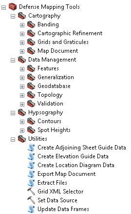
New toolsets were created and tools were organized into those toolsets.

There are additional new geoprocessing tools and functionality.
- Export Map Document is a new tool in the Utilities toolset that allows you to export to PDF, Production PDF, or a map package.
- Extract Files is a new tool in the Utilities toolset that extracts all files from a zipped folder.
- Extract And Clip Data is a new tool in the Geodatabase toolset that extracts features from a source geodatabase that intersects the input area of interest features, and clips and adds them to a target geodatabase.
- Set Data Source is a new tool in the Utilities toolset that sets the data source on layers within an MXD.
- Create Location Diagram Data is a new tool in the Cartographic Data toolset that creates the Location Diagram for a JOG map sheet.
- Update Data Frames is a new tool in the Utilities toolset that allows you to adjust the size of the data frames in the map document based on the product type.
- Naming conventions for files have been changed to match the product type. For example, TRD4 was renamed to TRD_4_0.
- MGCP TRD 4.1 and 4.2 schemas are now supported.
- The Rapid Graphic and Suppress Spot Heights tools now support JOG_A products.
- The installed map templates and the Populate Map Sheet Info tool were updated to allow updating a template multiple times.
- The Split Features tool was enhanced to work with polygon features.
- The EGB Hydro Centerline tool was renamed to Hydro Centerline.
- The Export Metadata tool was renamed to Export MGCP Metadata.
- The Import Metadata tool was renamed to Import MGCP Metadata.
Deprecated functionality
The TDS Metadata Ingest toolset was removed. It included the following tools:
- Export To MGCP
- Export To TGD
- Import From GIFD/TGD
- Import From MGCP
The Create and Smooth Contours model was removed from the Hypsography toolset, but you can still use the Create Contours and Simplify Contours tools separately.