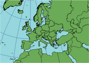
Description
Also called Cassini, this transverse cylindrical projection maintains scale along the central meridian and all lines parallel to it and is neither equal area nor conformal. It is most suited for large–scale mapping of areas predominantly north–south in extent.

Projection method
A transverse cylinder is projected conceptually onto the globe and is tangent along the central meridian. Cassini–Soldner is analogous to the Equirectangular projection in the same way Transverse Mercator is to the Mercator projection. The name Cassini–Soldner refers to the more accurate ellipsoidal version, developed in the 19th century and used in this software.
Point of tangency
Conceptually a line, specified as the central meridian.
Linear graticules
The equator, central meridian, and meridians 90° from the central meridian.
Properties
Shape
No distortion along the central meridian. Distortion increases with distance from the central meridian.
Area
No distortion along the central meridian. Distortion increases with distance from the central meridian.
Direction
Generally distorted.
Distance
Scale distortion increases with distance from the central meridian; however, scale is accurate along the central meridian and all lines perpendicular to the central meridian.
Limitations
Used primarily for large-scale mapping of areas near the central meridian. The extent on a spheroid is limited to 5° to either side of the central meridian. Beyond that range, data projected to Cassini–Soldner may not project back to the same position. Transverse Mercator often is preferred due to the difficulty in measuring scale and direction on Cassini–Soldner.
Uses and applications
Normally used for large–scale maps of areas predominantly north–south in extent.
Used for the Ordnance Survey of Great Britain and some German states in the late 19th century. Also used in Cyprus, former Czechoslovakia, Denmark, Malaysia, and the former Federal Republic of Germany.
Parameters
Desktop
- False Easting
- False Northing
- Central Meridian
- Scale factor
- Latitude of origin
Workstation
- Longitude of projection center
- Latitude of projection center
- False Easting (meters)
- False Northing (meters)