Available with Advanced license.
Summary
Converts arcs to preliminary regions in a new or existing coverage or appends preliminary regions to an existing region subclass.
Arcs are grouped into preliminary regions based on the unique value of the Line item and must form closed loops. The unique values are saved in the output subclass Region item.
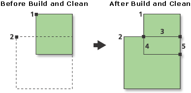
Illustration

Usage
The Input Coverage must have an AAT to specify the Input Region Item.
To create fully built regions from the preliminary regions, use Clean (or Build) with the POLY option on the Output Coverage.
The arcs in each group, which are determined by the unique value of the Input Region Item, must form closed loops. When the Input Region Item is not specified, each arc in the Input Coverage becomes a preliminary region and should form a closed loop.
Depending on the Input Region Item, arcs may be reused in any grouping with repeated use of this tool. In this way, duplicate or overlapping preliminary regions may be appended to the same subclass or to different subclasses.
The Output Region Item may be the same as the Input Region Item.
If the selection file has no arcs selected, the command will consider all arcs as selected. If the selection file has everything selected, everything is also selected for Line Coverage To Region.
If a selection file is not specified, all arcs are selected and available for grouping into regions. However, arcs in the Input Coverage that are already part of one or more fully structured regions are not available for appending to the subclass since they may not form closed rings when grouped.
If the Output Region Item already exists in the PATsubclass, the specified Output Region Item must have the same item definition as the existing one.
Region subclass names may be from 1 to 13 characters and cannot start with a numeric character.
When preliminary regions are appended to a subclass, the polygon topology is removed from the Output Coverage (or the Input Coverage) because it needs to be rebuilt.
-
This tool does not compute the area of the preliminary regions but sets the area values in the PATsubclass to zero and computes the perimeter. Building with the POLY option will calculate the area values.
Syntax
RegionClass_arc (in_cover, {out_cover}, out_subclass, {in_region_item}, {out_region_item}, {selection_file}, {method})| Parameter | Explanation | Data Type |
in_cover | The coverage containing the arcs from which the preliminary regions are created. | Coverage |
out_cover (Optional) | The coverage that will contain the preliminary regions. If the output coverage is not specified, the preliminary regions are created in the input coverage. | Coverage |
out_subclass | The name of the region subclass to be created or appended. | String |
in_region_item (Optional) | Item in the AAT of the input coverage whose values are used to group arcs into preliminary regions. The item is appended to the region PATsubclass. If not specified, each group of arcs becomes a preliminary region. | INFO Item |
out_region_item (Optional) | Output name for the input region Item to be used in the region PATsubclass instead of the Input Region Item name. | String |
selection_file (Optional) | The name of a selection file that can be used to specify a subset of the arcs to be grouped into preliminary regions. | File |
method (Optional) | Determines whether regions will be created from multiple rings of arcs or single rings of arcs.
| String |
Code Sample
RegionClass example (stand-alone script)
The following stand-alone script demonstrates how to create a region coverage from a line coverage.
# Name: RegionClass_Example.py
# Description: Creates regions in a line coverage
# Requirements: ArcInfo Workstation

# Import system modules
import arcpy
from arcpy import env

# Set environment settings
env.workspace = "C:/data"

# Set local variables
inCover = "tong_azone"
outSubclass = "districts"
method = "SINGLERING"

# Execute RegionClass
arcpy.RegionClass_arc(inCover, "", outSubclass, "", "", "", method)
arcpy.Build_arc(inCover, "POLY")
Environments
Licensing Information
- ArcGIS for Desktop Basic: No
- ArcGIS for Desktop Standard: No
- ArcGIS for Desktop Advanced: Requires ArcInfo Workstation installed