Summary
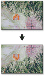
Reorients the raster by turning it over, from top to bottom, along the horizontal axis through the center of the raster. This may be useful to correct raster datasets that are upside down.
Illustration

Usage
This tool flips the grid from top to bottom along the horizontal axis through the center of the region.
You can save your output to BIL, BIP, BMP, BSQ, DAT, Esri Grid, GIF, IMG, JPEG, JPEG 2000, PNG, TIFF, or any geodatabase raster dataset.
When storing your raster dataset to a JPEG file, a JPEG 2000 file, or a geodatabase, you can specify a Compression Type type and Compression Quality within the Environment Settings.
Syntax
Flip_management (in_raster, out_raster)
| Parameter | Explanation | Data Type |
in_raster | Input raster dataset. | Mosaic Layer; Raster Layer |
out_raster | Output raster dataset. When storing the raster dataset in a file format, you need to specify the file extension:
When storing a raster dataset in a geodatabase, no file extension should be added to the name of the raster dataset. When storing your raster dataset to a JPEG file, a JPEG 2000 file, a TIFF file, or a geodatabase, you can specify a Compression Type and Compression Quality in the Environment Settings. | Raster Dataset |
Code sample
Flip example 1 (Python window)
This is a Python sample for the Flip tool.
import arcpy
arcpy.Flip_management("c:/data/image.tif", "c:/data/flip.tif")
Flip example 2 (stand-alone script)
This is a Python script sample for the Flip tool.
##====================================
##Flip
##Usage: Flip_management in_raster out_raster

import arcpy

arcpy.env.workspace = r"C:/Workspace"

##Flip a TIFF format image
arcpy.Flip_management("image.tif", "flip.tif")
Environments
Licensing information
- ArcGIS for Desktop Basic: Yes
- ArcGIS for Desktop Standard: Yes
- ArcGIS for Desktop Advanced: Yes