 |
This document is archived and information here might be outdated. Recommended version. |
IConstructPoint.ConstructParallel Method (ArcObjects .NET 10.5 SDK)
|
This document is archived and information here might be outdated. Recommended version. |
| ArcObjects Help for .NET developers > ArcObjects namespaces > Geometry > ESRI.ArcGIS.Geometry > Interfaces > IC > IConstructPoint Interface > IConstructPoint.ConstructParallel Method (ArcObjects .NET 10.5 SDK) |
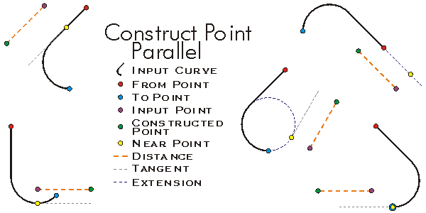
Constructs a point distance units from start, parallel to the tangent at the point nearest to start on the (extended) segment.
[Visual Basic .NET]
Public Sub ConstructParallel ( _
    ByVal Segment As ISegment, _
    ByVal extension As esriSegmentExtension, _
    ByVal start As IPoint, _
    ByVal distance As Double _
)
[C#]
public void ConstructParallel (
    ISegment Segment,
    esriSegmentExtension extension,
    IPoint start,
    double distance
);
[C++]
HRESULT ConstructParallel(
  ISegment* Segment,
  esriSegmentExtension extension,
  IPoint* start,
  double distance
);
[C++]

Parameters
Segment

  Segment is a parameter of type ISegment
extension

  extension is a parameter of type esriSegmentExtension
start

  start is a parameter of type IPoint
distance
  distance is a parameter of type double
ConstructParallel constructs a Point a specified distance from the input point in the direction parallel to the tangent of the nearest point on the extended input segment.
//The example shows how to construct a point parallel to the first segment
//of a selected polyline. Use ArcMap and the Object Editor to select the
//polyline.
public void ConstructPointParallelToLine(IMxDocument mxDocument)
{
IMap map=mxDocument.FocusMap;
IEnumFeature selectedFeatures=map.FeatureSelection as IEnumFeature;
selectedFeatures.Reset();
IFeature currentFeature=selectedFeatures.Next();
IConstructPoint constructionPoint=new PointClass();
while (currentFeature != null)
{
if (currentFeature.Shape.GeometryType == esriGeometryType.esriGeometryPolyline)
{
IGeometryCollection geometryCollection=currentFeature.Shape as IGeometryCollection;
ISegmentCollection segmentCollection=geometryCollection.get_Geometry(0) as ISegmentCollection;
ISegment segment=segmentCollection.get_Segment(0);
IPoint fromPoint=new PointClass();
segment.QueryFromPoint(fromPoint);
//add 10 to the x coordinate in order to get a diffrent point for this example
fromPoint.X=fromPoint.X + 10;
constructionPoint.ConstructParallel(segment, esriSegmentExtension.esriNoExtension, fromPoint, segment.Length / 2);
IPoint outPutPoint=constructionPoint as IPoint;
System.Windows.Forms.MessageBox.Show("Output point : " + outPutPoint.X + " , " + outPutPoint.Y);
}
currentFeature=selectedFeatures.Next();
}
}
' The example shows how to construct a point parallel to the first segment
' of a selected polyline. Use ArcMap and the Object Editor to select the
' polyline.
Public Sub t_constructParallel(ByVal pApp As ESRI.ArcGIS.Framework.IApplication)
Dim pID As New ESRI.ArcGIS.esriSystem.UID
pID="esriEditor.editor"
Dim pEditor As ESRI.ArcGIS.Editor.IEditor
pEditor=pApp.FindExtensionByCLSID(pID)
If pEditor.SelectionCount > 1 Then
MsgBox("select one polyline")
Exit Sub
End If
Dim pEnumFeat As ESRI.ArcGIS.Geodatabase.IEnumFeature
Dim pFeature As ESRI.ArcGIS.Geodatabase.IFeature
Dim i As Long
pEnumFeat=pEditor.EditSelection
Dim pSeg As ESRI.ArcGIS.Geometry.ISegment
Dim pGeoColl As ESRI.ArcGIS.Geometry.IGeometryCollection
Dim pPoint As ESRI.ArcGIS.Geometry.IPoint
pPoint=New ESRI.ArcGIS.Geometry.Point
Dim pCPoint As ESRI.ArcGIS.Geometry.IConstructPoint
pCPoint=New ESRI.ArcGIS.Geometry.Point
Dim pThroughPoint As ESRI.ArcGIS.Geometry.IPoint
pThroughPoint=New ESRI.ArcGIS.Geometry.Point
pFeature=pEnumFeat.Next
While Not pFeature Is Nothing
If pFeature.Shape.GeometryType=ESRI.ArcGIS.Geometry.esriGeometryType.esriGeometryPolyline Then
pGeoColl=pFeature.Shape
Dim pSegColl As ESRI.ArcGIS.Geometry.ISegmentCollection
pSegColl=pGeoColl.Geometry(0)
pSeg=pSegColl.Segment(0)
pSeg.QueryFromPoint(pThroughPoint)
pThroughPoint.X=pThroughPoint.X + 10
pCPoint.ConstructParallel(pSeg, ESRI.ArcGIS.Geometry.esriSegmentExtension.esriNoExtension, pThroughPoint, pSeg.Length / 2)
pPoint=pCPoint
MsgBox(pPoint.X & "," & pPoint.Y)
End If
pFeature=pEnumFeat.Next
End While
End Sub