ArcGIS for Maritime: Charting is a complete system for managing maritime data and products. It can be used for the creation and maintenance of traditional standards-based nautical products, such as electronic and paper charts, as well as to generate innovative products that enable groups of people inside and outside your organization to mine the rich content available in maritime data.
Maritime Charting is a desktop product that is part of the Esri platform. Maritime Charting is bundled with complementary components that include the following:
- Esri Production Mapping
- ArcGIS Data Reviewer for Desktop
- ArcGIS Workflow Manager for Desktop
- Task Assistant Manager
Together, these components provide the modern hydrographic community with a comprehensive solution to solve challenges and inefficiencies for chart production, while exposing the rich content contained within maritime data to a wide variety of GIS applications that can be used in planning, analysis, and information dissemination.
Maritime Charting production workflow
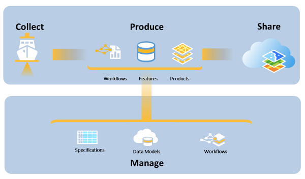
Maritime Charting organizes the production workflow into four stages: collect, manage, produce, and share. Using this common pattern as a framework, the ArcGIS for Desktop platform supports production workflows with enough flexibility to establish each organization’s specific steps and requirements.

Collect
When the system is initially set up for production, existing data must be migrated to the solution. This includes all maritime data, S-57 files, aids to navigation, and other chart features. The easiest way to achieve this is by bulk-loading existing S-57 files. By default, the NIS data schema is tailored to accommodate S-57 data, but as with any database schema, it can easily be augmented to store other data and feature attributes that an organization needs to manage.
Manage
ArcGIS for Desktop provides an efficient and intuitive data management system using the geodatabase. The Nautical Information System (NIS), the central element of Maritime Charting, is the repository for all data portrayed on electronic and paper charts. It is designed using Esri’s geodatabase and enterprise technology for data management.
Complementary to the NIS, the product library organizes nautical production. It is a multiuser geodatabase and is embedded in the ArcMap application of ArcGIS for Desktop. The product library allows you to do the following:
- Manage an organization’s portfolio of nautical products in a convenient hub, including a product’s metadata.
- Centralize information and behavior for cartographic and digital data production, data model information, and data validation rules.
- Standardize business rules, documents, and spatial information.
Maritime Charting supports nautical chart production that adheres to the International Hydrographic Organization’s (IHO) S-57 and S-4 standards, and MIL-PRF-89023 for Digital Nautical Charts (DNC). It includes the following:
- Preconfigured symbols and grids, and the attribute-level rule bases to define symbology
- Quality control through a combination of integrated standards-based validation checks
- A logically designed nautical data model that is based on S-57 objects and INT1 symbol categories to organize and accurately attribute features in a geodatabase
Workflow management links all the technical tools together and creates a cohesive and efficient production system to accomplish the following:
- Centrally manage and track units of work with simplified and standardized workflows
- Enable resources at production and management levels to assign, monitor, and follow predefined workflows
- Configurable to allow customized workflows to be developed and shared among users with different permission levels and access points
- Track and archive feature modifications across multiple databases by multiple personnel
Produce
Maritime Charting supports creating various information products such S-57 ENCs, DNC, raster, and paper nautical charts. It also does the following:
- Uses a suite of sophisticated tools designed for nautical production agencies in addition to a comprehensive suite of GIS tools provided with ArcGIS for Desktop for editing, visualizing, and analyzing information
- Uses a multiuser, versioned environment to allow compilers to simultaneously edit feature geometry and attribute information in coincident geography
- Integrates the data editing and product finishing environments in a single application with multiple views on information
- Provides confidence to compilers, reviewers, and quality assurance managers through a variety of runtime and preconfigured automated validation checks
- Protects an organization by ensuring longevity and traceability of edits to features and products through ArcGIS for Desktop archiving
- Provides a framework for exporting, publishing, and archiving electronic and cartographic nautical products
- Supports the creation of standards-compliant feature, image, and map services based on spatially enabled data
Share
The ArcGIS platform allows hydrographic offices to move beyond traditional dissemination and production practices. While still providing efficient dissemination practices for traditional products, the ArcGIS platform includes capabilities for sharing data and information products through ArcGIS Online as well as a wide variety of web services.