摘要
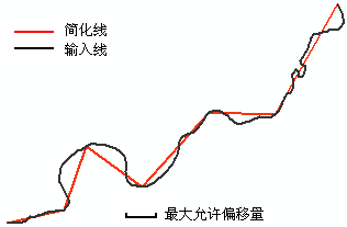
使用指定的最大偏移容差来简化输入要素。输出要素将包含原始输入折点的子集。
插图

用法
此工具使用与简化线工具的点移除方法(道格拉斯-普克简化算法)相同的算法。简化线工具提供了更多的参数,并会创建一个新的输出,而此工具则直接修改输入要素类。
此工具可按记录逐一概化要素。要素之间相互重合的多段线和面边界在运行完此工具后将可能不重合。
贝塞尔曲线段、圆弧段和椭圆弧段将转换为一组直线段。
此工具不会删除记录或要素。如果容差比某个面大,则该面将缩减为三个折点。
语法
Generalize_edit (in_features, {tolerance})| 参数 | 说明 | 数据类型 |
in_features | 要概化的面或线要素。 | Feature Layer |
tolerance (可选) | 此容差可设定最大允许偏移量,这会确定简化程度。该值会限制输出几何与输入几何的容许偏移距离。可以指定首选测量单位。默认值为要素单位。 | Linear unit |
代码实例
Generalize 示例(Python 窗口)
以下 Python 窗口脚本演示了如何在即时模式下使用 Generalize 函数:
import arcpy
arcpy.env.workspace = "C:\data\data.gdb"
arcpy.Generalize_edit("zones", "10 Feet")
Generalize 示例 2(独立脚本)
以下独立脚本示例演示了如何在先对要素进行简化然后再进行缓冲的工作流中使用 Generalize 函数:
#Name: BufferZones.py
#Purpose: Simplify features using the Generalize tool and then Buffer them

#Import script modules
import arcpy

try:
    #Set the workspace
    arcpy.env.workspace = "C:/data/data.gdb"

    #Set local parameters
    inFeatures = "zones"
    gTolerance = "4 Feet"
    copFeatures = "zones_cp"
    bufDist = "50 Miles"
    bufOutput = "zones_buff"

    #Since Generalize permanently updates the input, first make a copy of the original FC
    arcpy.CopyFeatures_management (inFeatures, copFeatures)

    #Use the Generalize tool to simplify the Buffer input to shorten Buffer processing time
    arcpy.Generalize_edit(copFeatures, gTolerance)

    #Buffer the output
    arcpy.Buffer_analysis(copFeatures, bufOutput, bufDist)

except Exception as err:
    print(err)
环境
许可信息
- ArcGIS for Desktop Basic: 否
- ArcGIS for Desktop Standard: 是
- ArcGIS for Desktop Advanced: 是