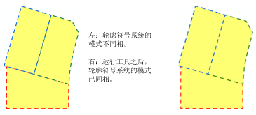
描述
此工具通常用于同步相邻面上的边界符号系统。此工具在由一个或多个线要素或面要素共用的折点处创建制图表达控制点。
插图

使用方法
制图表达控制点可用于控制图案化制图表达符号系统(如虚线)的相位调整。使用此工具可同步相邻面上经过相位调整的轮廓符号系统。
主要输入必须是使用要素类制图表达进行符号化的线或面要素图层。次要输入可以是点、线或面要素类;这种输入无需具有要素类制图表达;这些要素提供可供与主要输入要素进行比较的几何。
只将现有折点会被转换为制图表达控制点。该工具不会在没有折点的位置处创建制图表达控制点。
不会移除现有制图表达控制点。
如果只输入一个图层,则只会在三条线段的交点处创建制图表达控制点。如果输入次要要素,则会在线段相交处添加控制点。
仅当次要输入中包含要素类制图表达时,它才会接受制图表达控制点。这将允许两个输入中的要素同时接受制图表达控制点。如果未指定次要输入,此工具将只作用于主要输入,而且可对自相交要素进行处理。
对折点的修改将存储为要素制图表达上的几何覆盖。
两个输入图层均可接受多部分 (multipart) 几何。
语法
arcpy.cartography.SetRepresentationControlPointAtIntersect(in_line_or_polygon_features, {in_features})| 参数 | 说明 | 数据类型 |
in_line_or_polygon_features | 使用要素类制图表达进行符号化的输入线或面要素图层。 | Layer |
in_features (可选) | 包含重合要素的要素图层。这些要素可来自地理数据库、shapefile 或 coverage。 | Feature Layer |
代码示例
SetRepresentationControlPointAtIntersect 工具示例(Python 窗口)
以下 Python 窗口脚本演示了如何在即时模式下使用 SetRepresentationControlPointAtIntersect 工具。
import arcpy
from arcpy import env
env.workspace = "C:\data"

arcpy.SetRepresentationControlPointAtIntersect_cartography("parcels.lyr", "roads.lyr")
SetRepresentationControlPointAtIntersect 工具示例(独立 Python 脚本)
此独立脚本显示的是使用 SetRepresentationControlPointAtIntersect 工具的示例。
# Name: SetRepresentationControlPointAtIntersect_standalone_script.py
# Description: adds representation control points at locations where two or more features have coincident vertices
# Author: ESRI

# Import system modules
import arcpy
from arcpy import env

# Set environment settings
env.workspace = "C:/data"

# Set local variables
in_line_or_polygon_features = "parcels.lyr"
in_features = "roads.lyr"

# Execute Set Representation Control Point At Intersect
arcpy.SetRepresentationControlPointAtIntersect_cartography(in_line_or_polygon_features, in_features)
环境
此工具不使用任何地理处理环境。
许可信息
- Basic: 否
- Standard: 否
- Advanced: 是