Mit der Data Reviewer-Lizenz verfügbar.
When a technician corrects a record in the Reviewer table, it is a two-step process. The problem with the record must be corrected, whether it involves the feature geometry or attribution. Geometry errors can be resolved using the editing tools. Attribution errors can be corrected using the Attributes window in ArcMap or Update tab on the Feature Manager, which is available with Production Mapping.
Once the record has been corrected, it can be updated with correction information, which includes the status and correction notes. The status is the correction status, which can be Resolved or Mark As Exception. The correction notes explain the resolution.
After the correction information is populated, the CORRECTIONTECHNICIAN, CORRECTIONDATE, and CORRECTIONSTATUS fields are updated in the Reviewer table. If you have corrected a series of records that have required the same type of correction, you can update multiple records at once. For example, if you needed to correct attributes for 10 buildings and wanted to update their correction status all at once, you could do so.
- Start ArcMap.
- On the main menu, click Customize > Toolbars > Data Reviewer.
- Start a Reviewer session in one of the following:
-
Click the Reviewer Table button
 on the Data Reviewer toolbar.
- Select one or more records in the Reviewer table.
- Right-click the record or records and click Enter Correction Status.
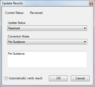
The Update Results dialog box appears. The current status of the selected records is displayed at the top of the dialog box.

- Click the Update Status drop-down arrow and choose an option.
- Resolved—The record has been corrected.
- Mark As Exception—The record either has not been or cannot be corrected.
- Click the Explanation drop-down arrow and choose an explanation.
- Per Guidance—The record has been evaluated based on directions given.
- None—There is no further explanation for the evaluation.
- Optionally type an explanation in the text box below the Explanation drop-down list.
- To automatically verify the record, check the Automatically verify result check box.
If this check box is checked, the record is moved to the verification state, and the VERIFICATIONTECHNICIAN, VERIFICATIONDATE, and VERIFICATIONSTATUS fields are populated for the selected records.
- Klicken Sie auf OK.
The CORRECTIONTECHNICIAN, CORRECTIONDATE, and CORRECTIONSTATUS fields are populated for the selected record or records.