Zusammenfassung
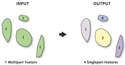
Erstellt durch Trennung von Multipart-Eingabe-Features eine Feature-Class mit Singlepart-Features.
Bild

Verwendung
Die Attribute der Eingabe-Features werden in der Ausgabe-Feature-Class beibehalten. Ein neues Feld, ORIG_FID, wird der Ausgabe-Feature-Class hinzugefügt und auf die IDs des Eingabe-Features gesetzt.
Die einzelnen Teile des Multipart-Eingabe-Features werden in der Ausgabe-Feature-Class zu einzelnen Singlepart-Features. Features, die bereits Singlepart sind, sind davon nicht betroffen.
Die meisten Ausgabe-Feature-Typen sind mit den Eingabetypen identisch (Eingabepolygone bleiben Polygone; Eingabelinien bleiben Linien). Eine Ausnahme ist allerdings, wenn die Eingabe-Features vom Typ "Multipoint" sind. Die Ausgabe-Feature-Class ist dann vom Typ "Point".
Mit dem Werkzeug Zusammenführen (Dissolve) lassen sich aus Singlepart-Features mit einem gemeinsamen Feldwert (beispielsweise ORIG_FID) Multipart-Features erstellen.
Syntax
MultipartToSinglepart_management (in_features, out_feature_class)
| Parameter | Erläuterung | Datentyp |
in_features | Die Eingabe-Features können jedes beliebige unterstützte Format aufweisen. | Feature Layer |
out_feature_class | Die Ausgabe-Feature-Class, die Features enthält, die sich je nach Eingabe-Feature-Typ ändern. | Feature Class |
Codebeispiel
MultipartToSinglepart - Beispiel 1 (Python-Fenster)
Mit dem folgenden Skript im Python-Fenster wird veranschaulicht, wie Sie die Funktion "MultipartToSinglepart" im unmittelbaren Modus verwenden.
import arcpy
arcpy.env.workspace = "C:/data"
arcpy.MultipartToSinglepart_management("landuse.shp",
                                       "c:/output/output.gdb/landuse_singlepart")
MultipartToSinglepart - Beispiel 2 (eigenständiges Skript)
Das folgende eigenständige Skript ist ein einfaches Beispiel für die Anwendung der Funktion "MultipartToSinglepart" in einer Skriptumgebung.
# Name: MultipartToSinglepart_Example2.py
# Description: Break all multipart features into singlepart features,
#              and report which features were separated.

# Import system modules
import arcpy

# Create variables for the input and output feature classes
inFeatureClass = "c:/data/gdb.gdb/vegetation"
outFeatureClass = "c:/data/gdb.gdb/vegetation_singlepart"

try:
    # Create list of all fields in inFeatureClass
    fieldNameList = [field.name for field in arcpy.ListFields(inFeatureClass)]

    # Add a field to the input this will be used as a unique identifier
    arcpy.AddField_management(inFeatureClass, "tmpUID", "double")

    # Determine what the name of the Object ID is
    OIDFieldName = arcpy.Describe(inFeatureClass).OIDFieldName

    # Calculate the tmpUID to the OID
    arcpy.CalculateField_management(inFeatureClass, "tmpUID",
                                    "!" + OIDFieldName + "!", "PYTHON")

    # Run the tool to create a new fc with only singlepart features
    arcpy.MultipartToSinglepart_management(inFeatureClass, outFeatureClass)

    # Check if there is a different number of features in the output
    #   than there was in the input
    inCount = int(arcpy.GetCount_management(inFeatureClass).getOutput(0))
    outCount = int(arcpy.GetCount_management(outFeatureClass).getOutput(0))

    if inCount != outCount:
        # If there is a difference, print out the FID of the input
        #   features which were multipart
        arcpy.Frequency_analysis(outFeatureClass,
                                 outFeatureClass + "_freq", "tmpUID")

        # Use a search cursor to go through the table, and print the tmpUID
        print("Multipart features from {0}".format(inFeatureClass))
        for row in arcpy.da.SearchCursor(outFeatureClass + "_freq",
                                         ["tmpUID"], "FREQUENCY > 1"):
            print(int(row[0]))
    else:
        print("No multipart features were found")

except arcpy.ExecuteError:
    print(arcpy.GetMessages())
except Exception as err:
    print(err.args[0])
Umgebung
- Aktueller Workspace
- Scratch-Workspace
- Standard-Ausgabe-Z-Wert
- M-Auflösung
- M-Toleranz
- Ausgabe-M-Domäne
- Ausgabe-Z-Domäne
- Ausgabe-Koordinatensystem
- Ausdehnung
- Ausgabe hat M-Werte
- Ausgabe hat Z-Werte
- Räumliches Gitter 1 der Ausgabe
- Räumliches Gitter 2 der Ausgabe
- Räumliches Gitter 3 der Ausgabe
- XY-Auflösung
- XY-Toleranz
- Z-Auflösung
- Z-Toleranz
Lizenzierungsinformationen
- ArcGIS for Desktop Basic: Ja
- ArcGIS for Desktop Standard: Ja
- ArcGIS for Desktop Advanced: Ja