ArcGIS Desktop

  • Dokumentation
  • Support

  • My Profile
  • Hilfe
  • Sign Out
ArcGIS Desktop

ArcGIS Online

Die Mapping-Plattform für Ihre Organisation

ArcGIS Desktop

Ein vollständiges professionelles GIS

ArcGIS Enterprise

GIS in Ihrem Unternehmen

ArcGIS for Developers

Werkzeuge zum Erstellen standortbezogener Apps

ArcGIS Solutions

Kostenlose Karten- und App-Vorlagen für Ihre Branche

ArcGIS Marketplace

Rufen Sie Apps und Daten für Ihre Organisation ab.

  • Dokumentation
  • Support
Esri
  • Anmelden
user
  • Eigenes Profil
  • Abmelden

ArcMap

  • Startseite
  • Erste Schritte
  • Karte
  • Analysieren
  • Verwalten von Daten
  • Werkzeuge
  • Erweiterungen

TIN Aspect

Mit der 3D Analyst-Lizenz verfügbar.

  • Zusammenfassung
  • Abbildung
  • Verwendung
  • Syntax
  • Codebeispiel
  • Umgebungen
  • Lizenzinformationen

Zusammenfassung

Extracts aspect information from an input TIN into an output feature class.

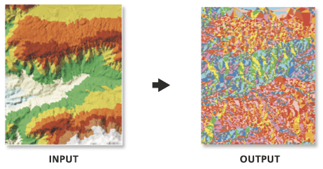
Produces a polygon feature class whose polygons are categorized by the input TIN's triangle aspect values.

Ältere Versionen:

This is a deprecated tool. To learn more about how this tool works click here to view archived documentation. This functionality has been added to the Surface Aspect tool.

Abbildung

TIN Aspect illustration

Verwendung

  • Aspect is expressed in degrees.

Syntax

TinAspect_3d (in_tin, out_feature_class, {class_breaks_table}, {aspect_field})
ParameterErläuterungDatentyp
in_tin

The input TIN.

Tin Layer
out_feature_class

The output feature class.

Feature Class
class_breaks_table
(optional)

An input table containing the classification breaks that will be used to classify the output feature class.

Table
aspect_field
(optional)

The field containing aspect values.

String

Codebeispiel

TIN Aspect Example (Python window)

The following Python Window script demonstrates how to use the TIN Aspectfunction in immediate mode.

import arcgisscripting
gp = arcgisscripting.create()

gp.CheckOutExtension("3D")
gp.workspace = "C:/data"
gp.TinAspect_3d("tin", "aspect.shp")

Umgebungen

  • Aktueller Workspace
  • Ausgabe-XY-Domäne
  • Ausgabe-Koordinatensystem
  • Ausdehnung
  • Scratch-Workspace
  • XY-Auflösung
  • XY-Toleranz

Lizenzinformationen

  • ArcGIS Desktop Basic: Erfordert 3D Analyst
  • ArcGIS Desktop Standard: Erfordert 3D Analyst
  • ArcGIS Desktop Advanced: Erfordert 3D Analyst

ArcGIS Desktop

  • Startseite
  • Dokumentation
  • Support

ArcGIS Plattform

  • ArcGIS Online
  • ArcGIS Desktop
  • ArcGIS Enterprise
  • ArcGIS for Developers
  • ArcGIS Solutions
  • ArcGIS Marketplace

Über Esri

  • Über uns
  • Karriere
  • Insider-Blog
  • User Conference
  • Developer Summit
Esri
Wir sind an Ihrer Meinung interessiert.
Copyright © 2018 Esri. | Datenschutz | Rechtliches