The Dynamic Update XY geoprocessing tool and the Toggle Automatic Update XY tool allow you to synchronize geometry and coordinate attribute edits made on point features and are meant to be used within existing data editing or creation workflows. If you are performing manual edits to attributes, the geometry will be updated accordingly, and if you move a feature, the attributes will be updated. To use this functionality, you must first set the tool properties: the feature classes that will be affected and the field in each feature class to be updated with the x- and y-coordinates. These properties are referenced by the tools during manual editing in a map document or when running either of the two tools.
- Start ArcMap.
- Ensure that the correct product library and production database are set.
- On the main menu, click Customize > Production > Production Properties.
The Production Properties dialog box appears.
- Click Aviation Properties.
- Click the ellipsis (...) next to Dynamic Update XY Settings.
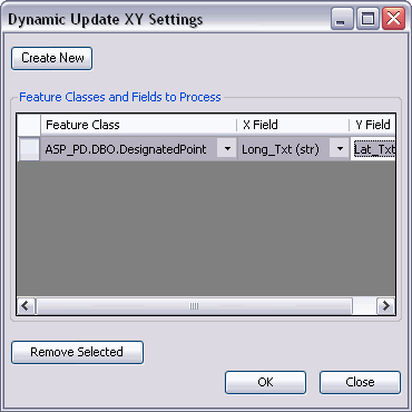
The Dynamic Update XY Settings dialog box appears.
- Click Create New.
- Click the Feature Class drop-down arrow and select the point feature
class to be updated.
Only point feature classes are allowed.
- Click the X Field drop-down arrow and select the field that contains the x-values.
- Click the Y Field drop-down arrow and select the field that contains the y-values.
The entry appears in the grid and can be edited or deleted by selecting it and clicking Remove Selected.
- Click OK to close the Dynamic Update XY Settings dialog box.
The Production Properties dialog box appears.
- Click OK to close the Production Properties dialog box.