ArcGIS Desktop

  • ArcGIS Pro
  • ArcMap

  • My Profile
  • Hilfe
  • Sign Out
ArcGIS Desktop

ArcGIS Online

Die Mapping-Plattform für Ihre Organisation

ArcGIS Desktop

Ein vollständiges professionelles GIS

ArcGIS Enterprise

GIS in Ihrem Unternehmen

ArcGIS Developers

Werkzeuge zum Erstellen standortbezogener Apps

ArcGIS Solutions

Kostenlose Karten- und App-Vorlagen für Ihre Branche

ArcGIS Marketplace

Rufen Sie Apps und Daten für Ihre Organisation ab.

  • Dokumentation
  • Support
Esri
  • Anmelden
user
  • Eigenes Profil
  • Abmelden

ArcMap

  • Startseite
  • Erste Schritte
  • Karte
  • Analysieren
  • Verwalten von Daten
  • Werkzeuge
  • Erweiterungen

Loop and lollipop routes

  • Loop routes
  • Lollipop routes

Loop and lollipop route types have certain rules that must be followed to be correctly calibrated and to maintain calibration. Once correctly calibrated, the routes can be managed and edited throughout ArcGIS Roads and Highways.

Hinweis:

Loop and lollipop routes are the only self-intersecting routes that are natively supported throughout ArcGIS Roads and Highways at this time. Other route geometries, such as branching, fish, or barbell routes, are supported by creating a gap in the route at the point of self-intersection before loading the route.

Loop routes

To be calibrated correctly in Roads and Highways, loop routes require at least two calibration points located at the same location, the beginning and end of the route.
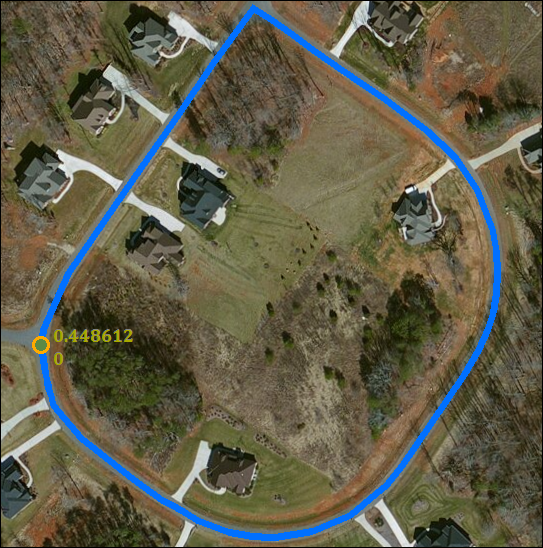
A loop route is calibrated with two calibration points at the beginning and end of the route with measures at 0 and 0.448612.

Since these two points are at the beginning and end of the route, their measures should be the smallest and largest measures on the route to calibrate the route in a strictly increasing or strictly decreasing manner. The Update Calibration Points geoprocessing tool will produce two calibration points at the beginning and end of the route, with the smallest and largest measures when calibrating a loop route.

Hinweis:

Loop routes with measures in the opposite direction of digitization require two additional calibration points along the loop. You can add these additional calibration points using the Update Calibration Points geoprocessing tool with GEOMETRY_LENGTH_2D or GEOMETRY_LENGTH_3D as the Calculation Method and MEASURE_DIRECTION as the Calibration Direction.

A loop route with the direction of calibration opposite the direction of digitization of the route, resulting in four calibration points on the route.

If the calibration points for your routes are being imported from another source, confirm there are at least two points at the beginning and end of the route to ensure it calibrates correctly.

Once loaded and calibrated, loop routes can be edited using Roads and Highways tools, loop routes can have events added and edited, and calibration points can be added and edited the same way as other route types.

Lollipop routes

Lollipop routes require only two calibration points to be calibrated correctly in Roads and Highways. One calibration point should be at the end of the stick portion of the route that doesn't meet the loop portion.
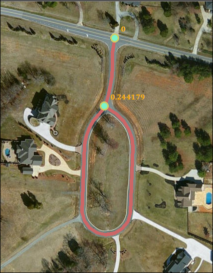
A lollipop route with one calibration point at the end of the stick portion and the other calibration point where the loop portion meets the stick

The other calibration point should be on the loop portion of the route where it meets the stick portion. To ensure a lollipop route calibrates correctly, the beginning and end of the route should be at these two locations. The direction of calibration of the route will determine which calibration point has the smaller measure and which has the larger measure. The Update Calibration Points geoprocessing tool will produce two calibration points at these locations when calibrating a lollipop route. If your calibration points are being imported from another source, ensure there are calibration points at the end of the stick portion not touching the loop portion and on the loop portion where it meets the stick.

Hinweis:

For lollipops to work correctly in Roads and Highways, they should be a single-part feature or a multipart feature with parts that begin and end at the junction of the stick and loop portions. If the lollipops are multipart and have a part that spans the stick and loop junction, the route may not be calibrated or edited correctly when using the Roads and Highways editing tools.

All lollipop routes should have only one calibration point for each time range at the location where the loop and stick portions of the route meet. Having more than one calibration point at this location in the same time range may result in the lollipop route not calibrating correctly.

Once loaded and calibrated, lollipop routes can be edited using Roads and Highways tools, lollipop routes can have events added and edited, and calibration points can be added and edited the same way as other route types.

ArcGIS Desktop

  • Startseite
  • Dokumentation
  • Support

ArcGIS

  • ArcGIS Online
  • ArcGIS Desktop
  • ArcGIS Enterprise
  • ArcGIS
  • ArcGIS Developer
  • ArcGIS Solutions
  • ArcGIS Marketplace

Über Esri

  • Über uns
  • Karriere
  • Esri Blog
  • User Conference
  • Developer Summit
Esri
Wir sind an Ihrer Meinung interessiert.
Copyright © 2021 Esri. | Datenschutz | Rechtliches