Mit der Business Analyst-Lizenz verfügbar.
Zusammenfassung
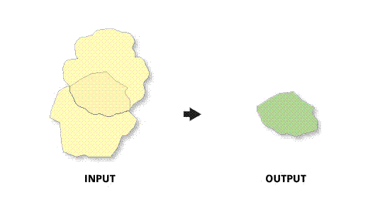
Calculates the amount of overlap between two or more trade areas.
Abbildung

Verwendung
The spatial reference of the output feature class will be the same as the trade area layer.
The trade area layer must be a polygon feature class.
This tool is primarily used to examine the amount of overlap between two or more trade areas.
In most cases, the trade area layers will be trade areas created with Business Analyst.
Only overlapping trade areas are valid inputs for this tool.
The output feature class is created from the actual area of overlap in the trade area features.
If trade areas do not overlap, the output feature class will be the same trade area input feature class.
Syntax
arcpy.ba.MeasureCannibalization(InputLayer, IDField, NameField, OutputFeatureClass, {UseSelectedFeatures}, {ReportName}, {ReportTitle}, {ReportOutputDirectory}, {ReportFormats})| Parameter | Erklärung | Datentyp |
InputLayer | The input feature class containing the trade areas used to determine amount of cannibalization. | Feature Layer |
IDField | Unique ID field in the trade area layer. | Field |
NameField | Unique name field in the trade area layer. | Field |
OutputFeatureClass | The output feature class that will contain the overlapped features. | Feature Class |
UseSelectedFeatures (optional) | The features used to measure cannibalization.
| Boolean |
ReportName (optional) | Name of the report. | String |
ReportTitle (optional) | Title of the report. | String |
ReportOutputDirectory (optional) | Report is created in this output folder. | Folder |
ReportFormats [ReportFormats,...] (optional) | One or more formats to which the report will be output. If you are using the Python function call, enter the values as a String in the following format: "FirstFormat; SecondFormat; ThirdFormat", etc. For example: "html;pdf;s.xlsx;s.xml;xlsx" (A String of desired format names delimited by semi-colons.)
| String |
Codebeispiel
MeasureCannibalzation Example (Stand-alone Script)
# Name: MeasureCannibalization.py
# Description: Measures cannibalization between two trade areas.
# Author: Esri

# Import system modules
import arcview
import arcpy

arcpy.ImportToolbox(r"C:\Program Files (x86)\ArcGIS\Desktop10.8\Business Analyst\ArcToolbox\Toolboxes\Business Analyst Tools.tbx")

# Acquire extension license
arcpy.CheckOutExtension("Business")

# Define input and output parameters for the Measure Cannibalization tool
InputLayer = "C:/temp/DetailedCustomerTA.shp"
IDField = "AREA_ID"
NameField = "AREA_DESC"
OutputFeatureClass = "C:/temp/Reports/Cannibalization.shp"
ReportName = "Cannibalization_Name"
ReportTitle = "Cannibalization_Report"
ReportOutputDirectory = "C:/temp/Reports"
ReportFormats="html;pdf;s.xlsx;s.xml;xlsx"

# Create a Measure Cannibalization output
arcpy.MeasureCannibalization_ba(InputLayer,
						IDField,
						NameField,
						OutputFeatureClass,
						UseSelectedFeatures,
						ReportName,
						ReportTitle,
						ReportOutputDirectory,
						ReportFormats)

# Release extension license
arcpy.CheckInExtension("Business")
Umgebungen
Dieses Werkzeug verwendet keine Geoverarbeitungsumgebungen.
Lizenzinformationen
- Basic: Erfordert Business Analyst
- Standard: Erfordert Business Analyst
- Advanced: Erfordert Business Analyst