ArcGIS Desktop

  • Documentation
  • Support

  • My Profile
  • Help
  • Sign Out
ArcGIS Desktop

ArcGIS Online

The mapping platform for your organization

ArcGIS Desktop

A complete professional GIS

ArcGIS Enterprise

GIS in your enterprise

ArcGIS for Developers

Tools to build location-aware apps

ArcGIS Solutions

Free template maps and apps for your industry

ArcGIS Marketplace

Get apps and data for your organization

  • Documentation
  • Support
Esri
  • Sign In
user
  • My Profile
  • Sign Out

Help

  • Home
  • Get Started
  • Map
  • Analyze
  • Manage Data
  • Tools
  • More...

Types of raster snapping properties

  • Raster snapping properties
  • The Snapping Environment window

When you use the editing classic snapping environment to trace raster data, you must choose to which part of the raster element you want your sketch or trace tool to snap. These choices are raster snapping properties. You can set these raster snapping properties using the Snapping Environment window. The following briefly explains the raster snapping properties.

Note:

While classic snapping is enabled, editing tools only use the classic snapping environment. However, georeferencing tools, the Measure tool, and other non-editing tools continue to use the snap settings on the Snapping toolbar.

Raster snapping properties

Centerlines—Snaps to the middle of the raster linear element, for example:

Centerline snapping

Corner—Snaps to the corner where two raster linear elements meet, for example:
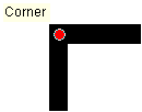
Corner snapping

Intersection—Snaps to the junction where three or more raster linear elements meet, for example:

Intersection snapping

Ends—Snaps to the endpoint of a raster linear element, for example:

Ends snapping

Solid—Snaps to the centerpoint of a raster solid, for example:

Solid snapping

The Snapping Environment window

Below is the Snapping Environment window with the ArcScan raster snapping properties listed in the Raster section of the tree.
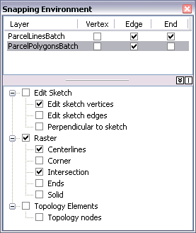
Snapping Environment window with raster snapping options

Related topics

  • About interactive vectorization

ArcGIS Desktop

  • Home
  • Documentation
  • Support

ArcGIS Platform

  • ArcGIS Online
  • ArcGIS Desktop
  • ArcGIS Enterprise
  • ArcGIS for Developers
  • ArcGIS Solutions
  • ArcGIS Marketplace

About Esri

  • About Us
  • Careers
  • Insiders Blog
  • User Conference
  • Developer Summit
Esri
Tell us what you think.
Copyright © 2018 Esri. | Privacy | Legal