ArcGIS Desktop

  • ArcGIS Pro
  • ArcMap

  • My Profile
  • Help
  • Sign Out
ArcGIS Desktop

ArcGIS Online

The mapping platform for your organization

ArcGIS Desktop

A complete professional GIS

ArcGIS Enterprise

GIS in your enterprise

ArcGIS for Developers

Tools to build location-aware apps

ArcGIS Solutions

Free template maps and apps for your industry

ArcGIS Marketplace

Get apps and data for your organization

  • Documentation
  • Support
Esri
  • Sign In
user
  • My Profile
  • Sign Out

Help

  • Home
  • Get Started
  • Map
  • Analyze
  • Manage Data
  • Tools
  • More...

Adding the terminal arrival area element to the chart layout

The Terminal Arrival Area (TAA) element appears in the plan view of an instrument approach procedure (IAP) and provides safe altitude and distance information. It contains three parts that reflect the straight-in, right-base, and left-base areas for the approach.
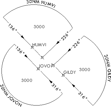
Example of a Terminal Arrival Area element

You can add this element to the map layout, as designated by your chart specification.

  1. Start ArcMap.
  2. On the main menu, click View > Layout View.
  3. Ensure that the TerminalProcedures table has been added to the table of contents.
  4. Open the Layer Properties dialog box and set a definition query such that the GFID matches the TerminalProcedure_ID value on the TAA feature class.

    Note:

    The query must return a minimum of two separate elements that represent the TAA sectors.

  5. On the main menu, click Customize > Toolbars > Aviation Terminal Procedure.
  6. Click the Terminal Arrival Area button Terminal Arrival Area on the Aviation Terminal Procedures toolbar.

The terminal arrival area element is added to the chart layout.

Related topics

  • Aviation data-driven elements and editing

ArcGIS Desktop

  • Home
  • Documentation
  • Support

ArcGIS Platform

  • ArcGIS Online
  • ArcGIS Desktop
  • ArcGIS Enterprise
  • ArcGIS for Developers
  • ArcGIS Solutions
  • ArcGIS Marketplace

About Esri

  • About Us
  • Careers
  • Esri Blog
  • User Conference
  • Developer Summit
Esri
Tell us what you think.
Copyright © 2020 Esri. | Privacy | Legal