ArcGIS Desktop

  • ArcGIS Pro
  • ArcMap

  • My Profile
  • Help
  • Sign Out
ArcGIS Desktop

ArcGIS Online

The mapping platform for your organization

ArcGIS Desktop

A complete professional GIS

ArcGIS Enterprise

GIS in your enterprise

ArcGIS for Developers

Tools to build location-aware apps

ArcGIS Solutions

Free template maps and apps for your industry

ArcGIS Marketplace

Get apps and data for your organization

  • Documentation
  • Support
Esri
  • Sign In
user
  • My Profile
  • Sign Out

Help

  • Home
  • Get Started
  • Map
  • Analyze
  • Manage Data
  • Tools
  • More...

Creating two segments that intersect

Available with Production Mapping license.

The Segment Segment Intersect function creates a point where two segments intersect.
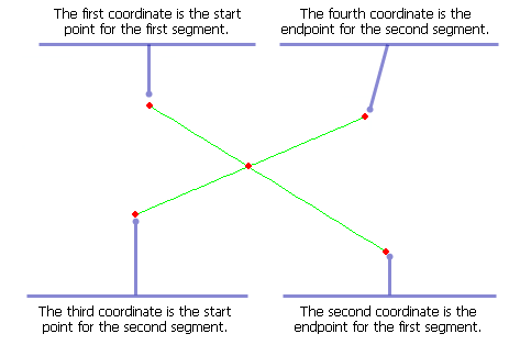
Example of input and output for the Segment Segment Intersection function
  1. Start ArcMap.
  2. On the menu bar, click Customize > Toolbars > Production Feature Builder.
  3. Click the Feature Builder button Feature Builder on the Production Feature Builder toolbar.

    The Feature Builder window appears.

    Tip:

    The Feature Builder window can be placed anywhere in ArcMap, or in the Table Of Contents window, with the aid of the arrows showing the possible placement positions.

  4. If the scratch dataset has not been added to the table of contents, click the Add Scratch Data Layers button Add scratch data layers at the top of the Feature Builder window.

    The dataset is added to the map using the current spatial reference.

  5. Choose Segment Segment Intersect in the list on the Functions tab.
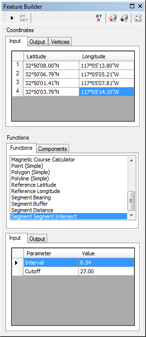
    Feature Builder window with the Segment Segment Intersection function selected

  6. Define a coordinate for the start point of the polyline by doing one of the following:
    • Click the Pinprick tool Pinprick on the Production Feature Builder toolbar and click on the map
    • Type the coordinates in the cells on the Input tab in the Coordinates area.

    Tip:

    To view the input coordinates on the map, double-click the row headers for each coordinate.

  7. Repeat step 6 to define a coordinates for the following:

    • Endpoint of the first segment
    • Start point of the second segment
    • Endpoint of the second segment

  8. If necessary, click the cell next to Interval and type a value.

    This is the length of the segments that are searched for an intersection between the coordinates and the cutoff point. The default unit is Nautical Miles.

    Tip:

    Right-click the parameter name and change the unit of measurement. If you change the unit of measurement after defining a value, the value is converted to the new unit of measurement, and you may need to redefine the value.

  9. Click the cell next to Cutoff and type a value.

    This is the maximum distance that can be searched for an intersection from the four coordinates specified. The default unit is Nautical Miles.

    Tip:

    Right-click the parameter name and change the unit of measurement. If you change the unit of measurement after defining a value, the value is converted to the new unit of measurement, and you may need to redefine the value.

  10. Click the Execute button Execute.

Two lines intersecting at a point are created.

ArcGIS Desktop

  • Home
  • Documentation
  • Support

ArcGIS Platform

  • ArcGIS Online
  • ArcGIS Desktop
  • ArcGIS Enterprise
  • ArcGIS for Developers
  • ArcGIS Solutions
  • ArcGIS Marketplace

About Esri

  • About Us
  • Careers
  • Esri Blog
  • User Conference
  • Developer Summit
Esri
Tell us what you think.
Copyright © 2020 Esri. | Privacy | Legal