Available with Production Mapping license.
With some data, such as maritime and aviation data, features are created and maintained based on textual descriptions of points, lines, and area in a data specification. These descriptions define the locations of features based on distances in relation to observable features or significant points. The measurements for the features are geodesic and ellipsoid. For example, an airspace boundary around a given airport can be defined as a geodesic arc starting from a point at an azimuth of 335 degrees and a distance of 7 nautical miles from the last surveyed airport center point and extending clockwise to an azimuth of 125 degrees.
Due to the complexity of these features, it is necessary to create them in steps using several different geometry types that include the following:
- Simple—A point, multipoint, polyline, or polygon feature.
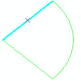
- Nonsimple—Features that can be produced based on a list of parameters that includes significant point coordinates, type information, azimuth, and distance values. The selected segment on the example below is a great circle arc, which depicts a bearing distance:

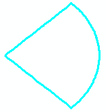
- Complex—Multipart features constructed from any combination of features/geometries that include at least one nonsimple or conflated part. The example below is a geodesic sector, which is composed of three nonsimple features: two great circle arcs and a geodesic arc:

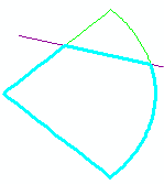
- Conflated—Features where all or part of the geometry has been incorporated into a multipart geometry. In the example below, the geodesic sector has been converted to a polygon using an ATS route, which is a line feature. The route intersected the geodesic sector to produce a set of polyline features. The features were then converted from polylines to a polygon.

Combined, these geometry types can be used to generate several features including loxodromes, airspace, geodesic arcs, and circles and other features necessary for aviation and maritime data.