Digital Aeronautical Flight Information File (DAFIF) is a collection of shapefiles that contains various aviation features such as Special Use Airspace, Navaids, Airports, and so on. This data can be imported into the AIS data model and mapping information can be found in Mapping Information for DAFIF and AIS data models.
- Start ArcMap.
- If necessary, create a new geodatabase with the AIS schema using the Create Aviation Geodatabase geoprocessing tool.
- Add the Import DAFIF tool to a toolbar by doing the following.
- Click Customize > Customize Mode.
- Click the Commands tab.
- In the Categories list, click Aviation.
- Drag and drop the
 button to the Aviation Data Management toolbar.
 The command appears on the toolbar.
- Click Close.
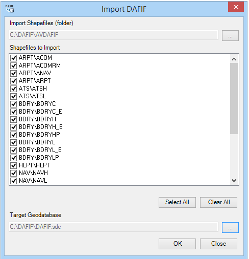
- Click the browse button next to the Import Shapefiles (folder) text box.
- Browse to the directory that contains the shapefiles and click Select.
The Shapefiles to Import list is populated with the list of shapefiles that will be imported into the geodatabase. By default, all the shapefiles are selected for importing.

- Click the browse button next to Target Geodatabase.
- Browse to the geodatabase into which the data will be imported.
- Click OK.
The Import DAFIF Shapefiles Into AIS Geodatabase dialog box appears and displays the progress of the import process. Information reported includes the number of features transferred from each shapefile to the corresponding feature class.
- Click OK to close the progress dialog box.