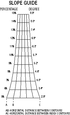
The TLM Slope Guide surround element is used to show the percentage of slope based on the map scale and contour interval.

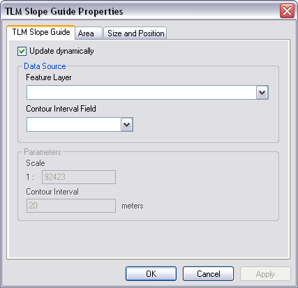
Once inserted, double-clicking the TLM Slope Guide allows you to access the TLM Slope Guide Properties dialog box. The Update dynamically check box on the TLM Slope Guide tab is checked by default. When this check box is checked, the TLM Slope Guide updates dynamically based on the current map scale and a field in a polygon feature class that contains the contour interval.
Unchecking the Update dynamically check box allows you to specify the scale and contour interval. However, a red box will display in place of the TLM Slope Guide when one of the following occur:
- The scale exceeds 250,000.
- The contour interval exceeds 200.
If the element needs to be altered after it is created, select the element in the layout view, click Convert To Graphics, and click Ungroup to ungroup the elements that were used to create it. Perform the required edits and regroup the elements by clicking Group.
- Start ArcMap.
- Verify that the map is in layout view.
- On the main menu, click Customize > Toolbars > Defense Mapping.
- On the Defense Mapping toolbar, click Defense Mapping > Surround Element > TLM Slope Guide.
A TLM Slope Guide displays in the map layout.
- Double-click the TLM Slope Guide.
The TLM Slope Guide Properties dialog box appears.

- Click the TLM Slope Guide tab.
The TLM Slope Guide tab appears with the Update dynamically check box checked by default.
- Click the Feature Layer drop-down arrow to select the feature layer you want to use.
- Click the Contour Interval Field drop-down arrow to select the field that contains the contour interval you want to use.
- To modify the scale and contour interval, do the following:
- Uncheck the Update dynamically check box.
The Parameters area becomes available.
- Type a scale not to exceed 250,000 in the Scale text box.
The default value is 50,000.
- Type a contour interval in the Contour Interval text box.
The default value is 20. The value specified cannot exceed 200.
- Uncheck the Update dynamically check box.
- Click OK.