Vector logos must be created inside ArcMap as ArcMap graphics to ensure that the chart will color separate. This can be done by first converting the raster logo image to a vector feature class layer, then to ArcMap vector graphics.
If you do not have ArcScan available, you'll need to install it from your ArcGIS for Desktop Standard or Advanced suite.
Image and database setup
The image needs to be 1-bit format/resolution; otherwise, the ArcScan toolbar will not recognize the image, and you will not be able to convert the logo into vectors. You also need to create a database to save the image and convert it to a vector.
- Obtain a 1-bit image of the logo to be used.
- Click the Catalog window button
 on the Standard toolbar in ArcMap.
- Browse to the location where you want to create your database.
- Right-click and click New, then click either File Geodatabase or Personal Geodatabase.
- Right-click the geodatabase, then click New > Feature Class to create a new feature class.
The New Feature Class dialog box appears.
- Type a logical name for the logo in the Name text box.
- In the Type area, click the Type of features stored in this feature class drop-down arrow and choose Polygon Features.
- Click Next.
- Choose Unknown for the geospatial reference.
- Click Next.
- In the XY Tolerance area, leave the default value for Unknown Units.
- Click Next.
- Choose the Default option if necessary.
- Click Next.
- Click a blank line under Field Name and create a new field.
- Click under Data Type and choose Text.
- Click Finish.
- Repeat the steps above for the creation of a line feature class.
- Close the map document when finished.
Vectorizing the image
The following steps outline the process required to vectorize the raster logo image.
- Open a new map document.
- Click Customize > Extensions to turn on the ArcScan extension if necessary.
- Click Customize > Toolbars and add the ArcScan toolbar.
- Click the Add Data button
 .
.
- Navigate to the location of the 1-bit image you want to use.
- Click Add.
- If a warning message appears stating that your image is missing spatial reference information, perform the following steps:
- Click OK.
- Click Add Data again, navigate to the database in which you created the polygon and line feature classes in Logos, then select them to be added.
- Click Add.
- In the Table Of Contents window, click the List By Source button
 .
.
- Right-click the added 1-bit image and click Properties.
- Click the Symbology tab.
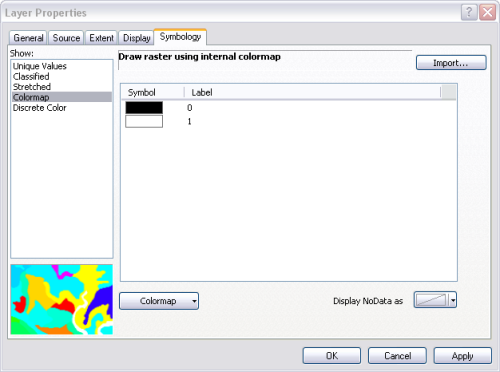
- In the Show list, click Classified.
The Compute Histogram message appears.

- Click Yes to compute the histogram.
- Click OK on the Layer Properties dialog box.
- Click the Production Start Editing button
 on the Production Editing toolbar.
- Verify that the image name displays in the Raster drop-down list on the ArcScan toolbar.
- On the ArcScan toolbar, click Vectorization > Vectorization Settings.

The Vectorization Settings dialog box appears.
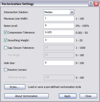
- Click the Intersection Solution drop-down arrow and choose Median.
- Type 1 in the Maximum Line Width text box.
- Type 0 in the Noise Level text box.
- If necessary, check the Compression Tolerance check box and type 0.025 in the text box.
- If necessary, check the Smoothing Weight check box and type 3 in the text box.
- If necessary, uncheck the Gap Closure Tolerance check box.
- Type 0 in the Hole Size text box if necessary.
- If necessary, uncheck the Resolve Corners check box.
- Click Apply.
- On the ArcScan toolbar, click Vectorization > Generate Features.

The Generate Features dialog box appears.
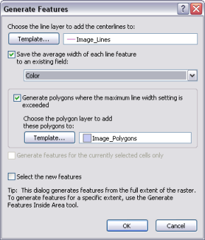
- If necessary, check the Save the average width of each line feature on an existing field check box.
- If necessary, check the Generate polygons where the maximum line width setting is exceeded check box.
- Click OK.
- Hide the visibility of the image layer by unchecking the check box next to its name on the Table Of Contents window.
- Make the polygon and/or polyline features visible by checking the check box next to its name on the Table Of Contents window.
Converting vectors to graphics
Since all the features are now polygons, you can use standard data editing tools to smooth, reshape, and add or delete features. You can also assign color using the layer and the Table Of Contents window. Once you have finished modifying the feature(s), continue with the following steps.
- Right-click the associated layer in the Table Of Contents window and click Convert Features to Graphics.
This should be either the polygon or the polyline feature class in which the image was converted.
- Click the all option.
- Click the features of layer drop-down arrow and choose the polygon feature class.
- In the Conversion conditions area, verify that the Only draw the converted graphics option is selected.
- Click the Target Annotation Group drop-down arrow and choose the polygon name graphic.
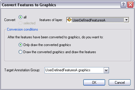
- Click OK.
Adding the logo graphics to the chart
You can now add the logo as vector graphics to your chart.
- Click the Select Elements button
 and use it to select all the graphics, or right-click the map layout and click Select All Elements.
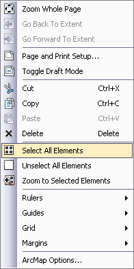
- Right-click the selected elements and click Group.
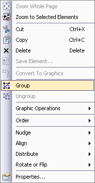
- Right-click the grouped graphics and click Copy.
- Open the product map document.
- If necessary, enable the Layout View.
- Right-click outside the data frame and click Paste.
- Save the map document by clicking the Save button
 on the Standard toolbar.
- Close ArcMap.
You have now converted a raster image into a vector and then into a graphic and used it as a logo in ArcMap.