ArcGIS Desktop

  • ArcGIS Pro
  • ArcMap

  • My Profile
  • Help
  • Sign Out
ArcGIS Desktop

ArcGIS Online

The mapping platform for your organization

ArcGIS Desktop

A complete professional GIS

ArcGIS Enterprise

GIS in your enterprise

ArcGIS for Developers

Tools to build location-aware apps

ArcGIS Solutions

Free template maps and apps for your industry

ArcGIS Marketplace

Get apps and data for your organization

  • Documentation
  • Support
Esri
  • Sign In
user
  • My Profile
  • Sign Out

Help

  • Home
  • Get Started
  • Map
  • Analyze
  • Manage Data
  • Tools
  • More...

Enabling BSB

To export BSB, you must enable the BSB setting before any nautical products are created under the CHART class. The following steps are to enable BSB.

  1. Start ArcMap.
  2. Right-click the CHART product class node in the Product Library window and click Properties.

    The Class Properties dialog appears.

  3. Click Nautical Environment on the left side of the Class Properties dialog box.

    The BSB property appears only if the current data model version for the class is defined.
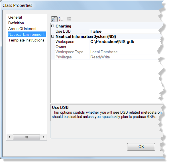
    Class Properties dialog box with BSB option
  4. Click the text box with the default False value next to Use BSB, click the drop-down arrow that appears and choose True.

The BSB metadata will now be exposed in the New Nautical Product wizard, and the BSB export option will now be available in the export format drop-down menu. You can choose the BSB export format when using the export nautical product functionality.

ArcGIS Desktop

  • Home
  • Documentation
  • Support

ArcGIS Platform

  • ArcGIS Online
  • ArcGIS Desktop
  • ArcGIS Enterprise
  • ArcGIS for Developers
  • ArcGIS Solutions
  • ArcGIS Marketplace

About Esri

  • About Us
  • Careers
  • Esri Blog
  • User Conference
  • Developer Summit
Esri
Tell us what you think.
Copyright © 2020 Esri. | Privacy | Legal