Available with Production Mapping license.
The Generate Straight Line Diagram wizard is used to create m-enabled line features that are used to symbolize events in the straight line diagram. The line features are created in a square area. The length of the lines span the entire width of the area. You can choose how much of the vertical space is filled with the lines in the straight line diagram. When specifying the vertical space, you can define what percentage of the vertical space is used by various portions of the straight line diagram. The percentage values must add up to 100.
The options for spacing change based on whether you choose to include events above and below the reference layer. If the events are all entirely above or below the reference layer, you are presented with five options:

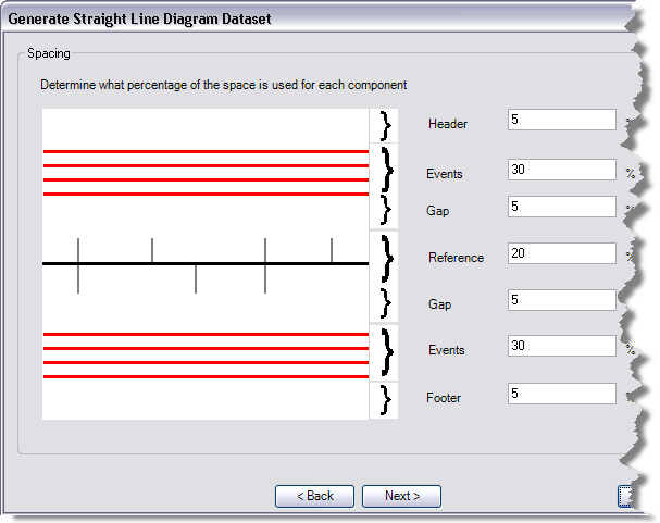
If the events are both above and below the reference layer, you are presented with seven options:

- Header and Footer—The features are created in a square area; however, the dimensions of the data frame where you want to add the events may not be square. Enter values for the header and footer to make the diagram in an area that is wider than it is high.
- Reference—The space that you give to the reference parameter is the amount of space that is used for the reference layer. The reference layer is created in the middle of this space.
- Events—There may be one or two of these properties based on the location of the events in relation to the reference layer. This property defines how much of the diagram is going to be filled with the event layers. The percentage of space for the event layers is evenly divided based on the number of events that have been selected.
- Gap—There may be one or two of these properties based on the location of the events in relation to the reference layer. The gap allows you to specify extra space that may appear between the reference layer and the events. For example, perhaps you place the reference layer with events above and below and you want to display the measures along the route below the reference layer. In this case, you might want to have a larger gap at the bottom of the reference layer than at the top.