ArcGIS Desktop

  • Documentation
  • Support

  • My Profile
  • Help
  • Sign Out
ArcGIS Desktop

ArcGIS Online

The mapping platform for your organization

ArcGIS Desktop

A complete professional GIS

ArcGIS Enterprise

GIS in your enterprise

ArcGIS for Developers

Tools to build location-aware apps

ArcGIS Solutions

Free template maps and apps for your industry

ArcGIS Marketplace

Get apps and data for your organization

  • Documentation
  • Support
Esri
  • Sign In
user
  • My Profile
  • Sign Out

Help

  • Home
  • Get Started
  • Map
  • Analyze
  • Manage Data
  • Tools
  • More...

Event shapes updates

You should not edit Esri Roads and Highways event feature class shapes directly using ArcGIS for Desktop editing tools or ArcGIS for Server REST services like the feature service. The supported way to edit event feature classes in Roads and Highways include the following:

  • In the ArcMap attribute table, edit the Route ID, From date, To date, measure columns, and other attributes—other than the shape—in an edit session.
  • Use the Roads and Highways for Server Roadway Characteristics Editor.
  • Use the Roads and Highways for Server Linear Referencing capability REST services.

If event shapes are inadvertently edited in a manner other than what is described above, the shapes for the events must be regenerated. Roads and Highways provides the ability to do so by right-clicking the updated event layer and clicking Update Event Shapes.
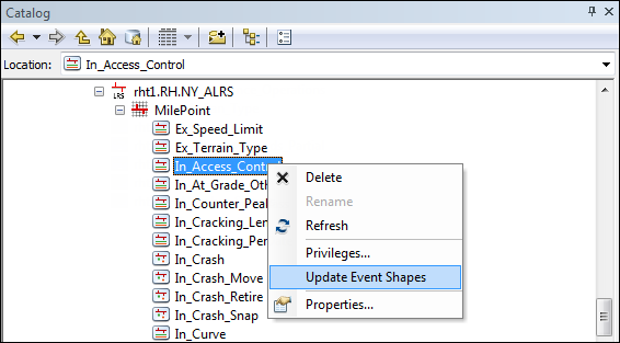
Update Event Shapes command

ArcGIS Desktop

  • Home
  • Documentation
  • Support

ArcGIS Platform

  • ArcGIS Online
  • ArcGIS Desktop
  • ArcGIS Enterprise
  • ArcGIS for Developers
  • ArcGIS Solutions
  • ArcGIS Marketplace

About Esri

  • About Us
  • Careers
  • Esri Blog
  • User Conference
  • Developer Summit
Esri
Tell us what you think.
Copyright © 2018 Esri. | Privacy | Legal