ArcGIS for Desktop

  • Documentation
  • Pricing
  • Support

  • My Profile
  • Help
  • Sign Out
ArcGIS for Desktop

ArcGIS Online

The mapping platform for your organization

ArcGIS for Desktop

A complete professional GIS

ArcGIS for Server

GIS in your enterprise

ArcGIS for Developers

Tools to build location-aware apps

ArcGIS Solutions

Free template maps and apps for your industry

ArcGIS Marketplace

Get apps and data for your organization

  • Documentation
  • Pricing
  • Support
Esri
  • Sign In
user
  • My Profile
  • Sign Out

ArcGIS Help

  • Home
  • Get Started
  • Map
  • Analyze
  • Manage Data
  • Tools
  • More...

Smoothing class boundaries and clumping classified output

Available with Spatial Analyst license.

The Boundary Clean tool will smooth the ragged edges of class boundaries and clump the classes. This operation increases the spatial coherency in the classes. Regions that are adjacent and belong to the same class may become connected.

  1. Open the Search window by clicking the Search window button Search on the Standard toolbar.
  2. In the window, type Boundary Clean and press Enter.
  3. In the search results, click Boundary Clean. This opens the Boundary Clean tool.
  4. On the tool dialog box, set the filtered output (or the output from any other processing) as the Input raster. For the Sorting technique, choose Ascending. Uncheck the optional parameter Run expansion and shrinking twice.
  5. Click OK to run the tool.

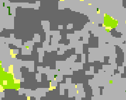
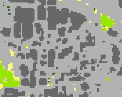
The following is an example of the output after the class boundaries have been smoothed. The first image is a zoomed-in area of a classified image. The second image is the same area after executing the boundary cleaning operation. As you can see, the boundary is smoothed in the second image. Some adjacent regions become connected.

Zoomed in section of image before boundary cleaning process:
Before boundary cleaning

After boundary cleaning:

After boundary cleaning

Related Topics

  • What is image classification?
  • Processing classified output
Feedback on this topic?

ArcGIS for Desktop

  • Home
  • Documentation
  • Pricing
  • Support

ArcGIS Platform

  • ArcGIS Online
  • ArcGIS for Desktop
  • ArcGIS for Server
  • ArcGIS for Developers
  • ArcGIS Solutions
  • ArcGIS Marketplace

About Esri

  • About Us
  • Careers
  • Insiders Blog
  • User Conference
  • Developer Summit
Esri
© Copyright 2016 Environmental Systems Research Institute, Inc. | Privacy | Legal