In certain circumstances, it may become necessary to update the measure values in an event table. For example:
- Using an event table to reference multiple route references, each of which has its own unit of measure
- Keeping measures up-to-date when a route is recalibrated or realigned
Using with multiple route references
In many agencies, event data is collected against multiple route reference systems. For example, a DOT might use both a reference marker system and a milepost system. Some event data, such as accident locations and maintenance activities, is recorded using the reference marker system, while other event data, such as pavement condition or capital improvement projects, is recorded using the milepost system of measurement.
Every year, a DOT manager is required to determine which sections of highway need to be resurfaced. Using a pavement event table, a manager could determine which segments of pavement have fallen into disrepair. The manager does not, however, want to resurface highways with certain types of accident histories without first performing a safety analysis. The reason for this is that speeds may increase on the new pavement, which could further increase the accident rate.
To make a well-informed decision, it will be necessary to combine and analyze the event data that has been collected against the different route references. The pavement scores are based on milepost values, while the accident data is based on the reference marker system. To combine the event data, the pavement events must be transformed to the reference marker system, or the accident events must be transformed to the milepost system.
The figure below shows an example where it would be necessary to transform events to analyze events recorded using one route reference with events recorded using another route reference.

Keeping event measures up-to-date
Measure locations tie an event to a particular location along a route. When the measures of a route are altered, the events will no longer be mapped to the same position along their routes.
In some cases, this is the desired result. For example, if the measures along a stream need calibration to match up to known mileages at gauging stations, and the location of fish habitat event data was collected using the gauging stations, nothing needs to be done to the event data when the route measures are altered.
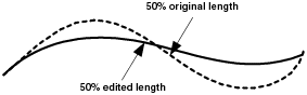
In other cases, data on the location of the events when they are mapped must be maintained. For example, if a highway is realigned, the measure of events describing the location of road signs must be updated to maintain their original positions.
The following figure shows an example of how realigning a route causes measure values to change. Events located on this route will no longer be in the same position.
If changes in route measures are linear along the length of a route, an equation can be applied to the event measures. For example, if a route's measures are multiplied by a factor of 1,000 to convert from kilometers to meters, all event measures can also be multiplied by 1,000.
If changes in route measures are nonlinear, such as what happens during a realignment procedure, the Transform Route Events tool can be used to recalculate the measures in an event table to maintain the real-world locations.