ArcGIS for Desktop

  • Documentation
  • Pricing
  • Support

  • My Profile
  • Help
  • Sign Out
ArcGIS for Desktop

ArcGIS Online

The mapping platform for your organization

ArcGIS for Desktop

A complete professional GIS

ArcGIS for Server

GIS in your enterprise

ArcGIS for Developers

Tools to build location-aware apps

ArcGIS Solutions

Free template maps and apps for your industry

ArcGIS Marketplace

Get apps and data for your organization

  • Documentation
  • Pricing
  • Support
Esri
  • Sign In
user
  • My Profile
  • Sign Out

Help

  • Home
  • Get Started
  • Map
  • Analyze
  • Manage Data
  • Tools
  • More...

Chamberlin trimetric

  • Description
  • Projection method
  • Linear graticules
  • Properties
  • Limitations
  • Uses and applications
  • Parameters

Description

This is the standard projection developed and used by the National Geographic Society for continental mapping. The distance from three input points to any other point is approximately correct.
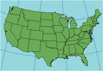
Illustration of Chamberlin trimetric projection

Projection method

Modified planar

Linear graticules

None

Properties

Shape

Shape distortion is low throughout if the three points are placed near the map limits.

Area

Areal distortion is low throughout if the three points are placed near the map limits.

Direction

Low distortion throughout

Distance

Nearly correct representation of distance from three widely spaced points to any other point

Limitations

The three selected input points should be widely spaced near the edge of the map limits.

Chamberlin trimetric can only be used in ArcInfo Workstation as an output projection because the inverse equations (Chamberlin trimetric to geographic) have not been implemented.

You can't project an ArcInfo Workstation grid or lattice to Chamberlin trimetric because the inverse equations are required.

Uses and applications

Used by the National Geographic Society as the standard map projection for most continents

Parameters

Supported in ArcInfo Workstation only

ArcInfo Workstation

  • Longitude of point A
  • Latitude of point A
  • Longitude of point B
  • Latitude of point B
  • Longitude of point C
  • Latitude of point C
Note:

Supported on spheres only.

geographic_coordinate_systems.pdf

A geographic coordinate systems pdf file which contains lists of supported gcs and vcs.

projected_coordinate_systems.pdf

A projected coordinate systems pdf file which contains lists of supported pcs.

geographic_transformations.pdf

A geographic transformations pdf file which contains lists of supported geographic and vertical transformations.

Related Topics

  • List of supported map projections
Feedback on this topic?

ArcGIS for Desktop

  • Home
  • Documentation
  • Pricing
  • Support

ArcGIS Platform

  • ArcGIS Online
  • ArcGIS for Desktop
  • ArcGIS for Server
  • ArcGIS for Developers
  • ArcGIS Solutions
  • ArcGIS Marketplace

About Esri

  • About Us
  • Careers
  • Insiders Blog
  • User Conference
  • Developer Summit
Esri
© Copyright 2016 Environmental Systems Research Institute, Inc. | Privacy | Legal