ArcGIS for Desktop

  • Documentation
  • Pricing
  • Support

  • My Profile
  • Help
  • Sign Out
ArcGIS for Desktop

ArcGIS Online

The mapping platform for your organization

ArcGIS for Desktop

A complete professional GIS

ArcGIS for Server

GIS in your enterprise

ArcGIS for Developers

Tools to build location-aware apps

ArcGIS Solutions

Free template maps and apps for your industry

ArcGIS Marketplace

Get apps and data for your organization

  • Documentation
  • Pricing
  • Support
Esri
  • Sign In
user
  • My Profile
  • Sign Out

Help

  • Home
  • Get Started
  • Map
  • Analyze
  • Manage Data
  • Tools
  • More...

Cube

  • Description
  • Projection method
  • Linear graticules
  • Properties
  • Limitations
  • Uses and applications

Description

A faceted projection that is used for ArcGlobe.
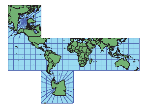
Illustration of a Cube projection

Projection method

The world is projected onto a six-sided figure with square sides.

Linear graticules

The meridians and parallels are straight lines.

Properties

Shape

Shapes are not maintained.

Area

Areas are not maintained.

Direction

Between +45° and -45° latitude, north, south, east, and west directions are accurate, but general directions are not. On the polar facets, directions are true from the center.

Distance

Between +45° and -45° latitude, scale is correct.

Limitations

Not recommended for general mapping.

Uses and applications

Used for ArcGlobe. Suitable for educational uses.

Related Topics

  • List of supported map projections
Feedback on this topic?

ArcGIS for Desktop

  • Home
  • Documentation
  • Pricing
  • Support

ArcGIS Platform

  • ArcGIS Online
  • ArcGIS for Desktop
  • ArcGIS for Server
  • ArcGIS for Developers
  • ArcGIS Solutions
  • ArcGIS Marketplace

About Esri

  • About Us
  • Careers
  • Insiders Blog
  • User Conference
  • Developer Summit
Esri
© Copyright 2016 Environmental Systems Research Institute, Inc. | Privacy | Legal