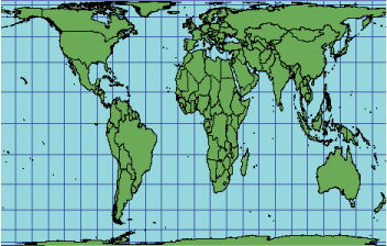
Description
Lambert first described this equal area projection in 1772. It has been used infrequently.

Projection method
A normal perspective projection onto a cylinder tangent at the equator.
Points of intersection
The equator.
Linear graticules
In the normal, or equatorial aspect, all meridians and parallels are perpendicular straight lines. Meridians are equally spaced and 0.32 times the length of the equator. Parallels are unequally spaced and farthest apart near the equator. Poles are lines of length equal to the equator.
Properties
Shape
Shape is true along the standard parallels of the normal aspect. Distortion is severe near the poles of the normal aspect.
Area
There is no area distortion.
Direction
Local angles are correct along standard parallels or standard lines. Direction is distorted elsewhere.
Distance
Scale is true along the equator. Scale distortion is severe near the poles.
Limitations
Recommended for narrow areas extending along the central line. Severe distortion of shape and scale near the poles.
Uses and applications
Suitable for equatorial regions.
Parameters
Desktop
- False Easting
- False Northing
- Central Meridian
- Standard Parallel 1
Workstation
- Enter projection type (1, 2, or 3):
Type 1 parameters
- Longitude of Central Meridian
- Latitude of standard parallel:
Type 2 parameters
- Longitude of 1st point
- Latitude of 1st point
- Longitude of 2nd point
- Latitude of 2nd point
- Scale factor:
Type 3 parameters
- Longitude of center of projection
- Latitude of center of projection
- Azimuth
- Scale factor