ArcGIS for Desktop

  • Documentation
  • Pricing
  • Support

  • My Profile
  • Help
  • Sign Out
ArcGIS for Desktop

ArcGIS Online

The mapping platform for your organization

ArcGIS for Desktop

A complete professional GIS

ArcGIS for Server

GIS in your enterprise

ArcGIS for Developers

Tools to build location-aware apps

ArcGIS Solutions

Free template maps and apps for your industry

ArcGIS Marketplace

Get apps and data for your organization

  • Documentation
  • Pricing
  • Support
Esri
  • Sign In
user
  • My Profile
  • Sign Out

Help

  • Home
  • Get Started
  • Map
  • Analyze
  • Manage Data
  • Tools
  • More...

Vertical Near-Side Perspective

  • Description
  • Projection method
  • Point of contact
  • Linear graticules
  • Properties
  • Limitations
  • Uses and applications
  • Parameters

Description

Unlike the orthographic projection, this perspective projection views the globe from a finite distance. This perspective gives the overall effect of the view from a satellite.

Learn about the Orthographic projection
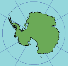
Illustration of the vertical near-side perspective projection

Projection method

Planar perspective projection—viewed from a specified distance above the surface. All aspects are either circular or an area less than a full hemisphere.

  • Polar aspect—meridians are straight lines radiating from the center, and the lines of latitude are projected as concentric circles that become closer toward the edge of the globe.
  • Equatorial aspect—the central meridian and the equator are straight lines. The other meridians and parallels are elliptical arcs.

Point of contact

A single point located anywhere on the globe.

Linear graticules

  • All aspects—the central meridian of the projection.
  • Equatorial aspect—the equator.
  • Polar aspect—all meridians.

Properties

Shape

Minimal distortion near the center; maximal distortion near the edge.

Area

Minimal distortion near the center; maximal distortion near the edge.

Direction

True direction from the central point.

Distance

The radial scale decreases with distance from the center.

Limitations

Limited to a view less than 90° from the central point.

Uses and applications

Uses of this projection are aesthetic more than technical. The most commonly used aspect for this purpose is the oblique.

Parameters

Desktop

  • False Easting
  • False Northing
  • Longitude of center
  • Latitude of center
  • Height

Workstation

  • Radius of the sphere of reference
  • Height of perspective point above sphere
  • Longitude of center of projection
  • Latitude of center of projection
  • False Easting (meters)
  • False Northing (meters)
Note:

Supported on spheres only.

geographic_coordinate_systems.pdf

A geographic coordinate systems pdf file which contains lists of supported gcs and vcs.

projected_coordinate_systems.pdf

A projected coordinate systems pdf file which contains lists of supported pcs.

geographic_transformations.pdf

A geographic transformations pdf file which contains lists of supported geographic and vertical transformations.

Related Topics

  • List of supported map projections
Feedback on this topic?

ArcGIS for Desktop

  • Home
  • Documentation
  • Pricing
  • Support

ArcGIS Platform

  • ArcGIS Online
  • ArcGIS for Desktop
  • ArcGIS for Server
  • ArcGIS for Developers
  • ArcGIS Solutions
  • ArcGIS Marketplace

About Esri

  • About Us
  • Careers
  • Insiders Blog
  • User Conference
  • Developer Summit
Esri
© Copyright 2016 Environmental Systems Research Institute, Inc. | Privacy | Legal