CAD features in ArcGIS for Desktop are aggregate collections of geometry contained in the source CAD drawing. Integrating them generally requires additional filtering with a definition query to narrow the collection to features on a particular drawing layer, of a certain color or line type, or other properties.
In a map document you can define a query in the Layer Properties dialog box for each feature layer. Definition queries display what is passed to geoprocessing tools. Using them can also help ensure predictable results for others who may open the map document and perform analysis or load the CAD data into a geodatabase.
To open the dialog box, double-click the CAD feature layer in the table of contents, or right-click the layer and click Properties on the context menu.
Definition Query tab
The Definition Query tab is where you can filter the display of CAD features. Saving the map document saves the query as a property of the feature layer.
Type a definition query
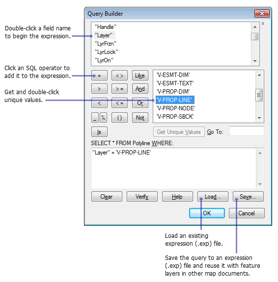
You can type an SQL expression directly in the Definition Query text box, or you can open Query Builder to help you create one. The SQL statement SELECT * FROM forms the first part of the expression and is automatically supplied for you.
Examples
- This example displays all CAD features on the drawing layer V-PROP-LINE: "Layer" = 'V-PROP-LINE'.
- This example displays all CAD features on the drawing layer V-CTRL that are Point entities: "Layer" = 'V-CTRL' AND "Entity" = 'Point'.
Open Query Builder
Click Query Builder to create a query graphically. The dialog box displays the fields and values contained in the CAD feature class attribute table. You can browse and click them to define the selection criteria.

Load an expression file
Click Load to load a predefined SQL expression from an expression (.exp) file.
Create an expression file
Click Save to save your SQL expression to an expression (.exp) file.
Remove the query
Deleting all expressions in the Definition Query text box effectively removes the definition query from the feature layer.