ArcGIS for Desktop

  • Documentation
  • Pricing
  • Support

  • My Profile
  • Help
  • Sign Out
ArcGIS for Desktop

ArcGIS Online

The mapping platform for your organization

ArcGIS for Desktop

A complete professional GIS

ArcGIS for Server

GIS in your enterprise

ArcGIS for Developers

Tools to build location-aware apps

ArcGIS Solutions

Free template maps and apps for your industry

ArcGIS Marketplace

Get apps and data for your organization

  • Documentation
  • Pricing
  • Support
Esri
  • Sign In
user
  • My Profile
  • Sign Out

Help

  • Home
  • Get Started
  • Map
  • Analyze
  • Manage Data
  • Tools
  • More...

Using the Limited Adjustment Area tool

You can limit the scope of an adjustment area by using the Limited Adjustment Area tool New Limited Adjustment Area. This tool is only available for the Rubbersheet adjustment method.

This tool allows you to draw a polygon shape around only the features you want to adjust. Any features that are outside this polygon area will not be affected by the adjustment, regardless of whether they are selected. The Limited Adjustment Area tool provides similar anchoring as identity links. However, in cases where you must add many identity links, using the Limited Adjustment Area tool may save you time.
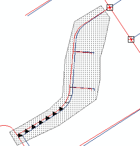
Limited adjustment area
  1. Click the New Limited Adjustment Area tool New Limited Adjustment Area on the Spatial Adjustment toolbar.
  2. Draw a polygon around the area you want to rubbersheet and double-click to complete the polygon. Features outside this polygon will not be affected during the adjustment. You can create multiple limited adjustment areas with the Limited Adjustment Area tool.
  3. Click Clear Limited Adjustment Area Clear Limited Adjustment Area to remove the limited adjustment area polygon.

Related Topics

  • About spatial adjustment rubbersheeting
  • Choosing a rubbersheet method
  • Creating identity links
Feedback on this topic?

ArcGIS for Desktop

  • Home
  • Documentation
  • Pricing
  • Support

ArcGIS Platform

  • ArcGIS Online
  • ArcGIS for Desktop
  • ArcGIS for Server
  • ArcGIS for Developers
  • ArcGIS Solutions
  • ArcGIS Marketplace

About Esri

  • About Us
  • Careers
  • Insiders Blog
  • User Conference
  • Developer Summit
Esri
© Copyright 2016 Environmental Systems Research Institute, Inc. | Privacy | Legal