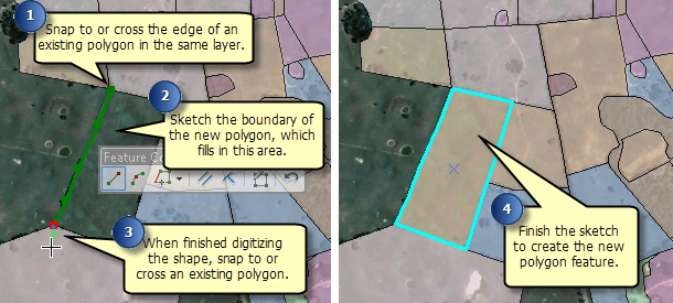
If you are creating polygons of land uses, soils, counties, or property ownership, for example, you often need to create polygons next to one another. The polygons should share a border, but you want to avoid digitizing the border twice or having overlaps or spaces between polygons. You can use the Auto-Complete construction tools when creating new polygons to help ensure that your data forms a continuous fabric. The new polygon can share a border with one or more existing polygons, although the polygons must all be from the same layer as the new feature you are creating. There are two construction tools you can use to create adjoining polygons: Auto-Complete Polygon and Auto-Complete Freehand.
With Auto-Complete Polygon, you can digitize a new polygon that adjoins an existing polygon, using the existing polygon's geometry and the edit sketch to define the edges of the new polygon.

Auto-Complete Freehand also appends polygons to existing ones, but you create the shape of the new polygon by drawing a line that follows the movement of your pointer. The new segments are smoothed into Bézier curves when you are finished.
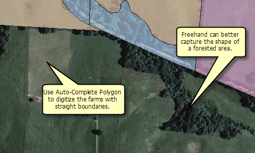
When creating adjoining polygons, you can use a combination of these tools. Most of the time, you will use the Auto-Complete Polygon tool since it provides the flexibility of using different construction methods to create shapes. Auto-Complete Polygon segments can be straight, curved, or traced from other features and created at exact measurements or lengths. However, sometimes the polygons you want to create may be more free-form or have curves that do not need to be precisely drawn. In those cases, you can use the Auto-Complete Freehand tool. For example, when you are digitizing a layer of land cover, you might use the Auto-Complete Polygon tool to create agricultural fields with straight boundaries and draw lakes or forested areas with the Auto-Complete Freehand tool so you can more easily digitize the curved shapes.

- Click a polygon feature template in the Create Features window.
- Click the Auto-Complete Polygon tool
 or the Auto-Complete Freehand tool
  on the Create Features window.
- Draw the new polygon. The new shape must cross the features in at least two places or the tool will fail. You can snap to an edge or overshoot the existing feature.
- With the Auto-Complete Polygon tool, you can change the shape of the sketch segment by clicking a construction method type on the Editor toolbar or on the Feature Construction mini toolbar. Segments can be created using a variety of methods—for example, as straight lines, with curves, or traced from the shapes of other features. You can also use keyboard shortcuts or right-click to access a menu of commands to help you place vertices in the sketch.
- With the Auto-Complete Freehand tool, click once where you want to start the line. You do not need to hold down the mouse button as you are creating the new polygon's shape. The new polygon's boundary follows the movements of your pointer. Hold down the SPACEBAR to snap to an existing polygon.
- Finish the feature.
- With the Auto-Complete Polygon tool, double-click to finish the sketch.
- With the Auto-Complete Freehand tool, you just need to click once to finish drawing the freehand shape and create the feature. The freehand drawing line is automatically smoothed into Bézier curves (the existing segments that are now shared with the new feature are not smoothed).