Sometimes you need to create a polygon with a hole in it or even a polygon with both a hole and an interior polygon. To create these kinds of polygons, you need to create a multipart feature.
When you create a polygon with an island inside it, the outer and inner areas are all one feature. This means that clicking either polygon will select both of them, and the attributes of the feature are stored in just one row in a table.
Donut polygons are commonly used with administrative boundaries. For example, a city may have unincorporated areas within its limits, or school districts may have holes or discontinuities. Islands might be useful for mapping land covers or habitats, such as where two groups of similar trees are separated by a grassy area or there is land mass surrounding a water body that has islands in it.
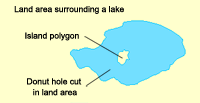
In the graphic below, the land mass has a donut hole (where the lake is) cut in it, then an island polygon is inside the hole. The lake polygon has a donut hole (where the island is) cut in it as well.

- Click a polygon feature template in the Create Features window.
- Click a construction tool and method and digitize the outer boundary of the polygon, without finishing the sketch.
- Hold down the SHIFT key and click, or right-click and click Finish Part.
- Click inside the polygon and sketch the inner boundary.
- If you are creating a donut polygon, finish the sketch. To create an island, finish the part and create another sketch inside the hole, then finish the sketch.