Available with Standard or Advanced license.
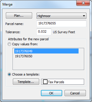
New parcels can be created by merging existing parcels in the parcel fabric. Adjacent parcels can be merged to create a single parcel, and disjoint parcels can be merged to create multipart parcels. The parcels being merged are saved as historic parcels. On the Merge dialog box, you can choose to copy attribute values from one of the existing parcels or use the attributes from a specified feature template.

After merging parcels, the original parent parcels will still be visible if your fabric is set to Show all parcels under the History tab of the parcel fabric Layer Properties dialog box. To turn off the display of historic parcels, choose Show a view of the fabric parcels.
A points tolerance is used for merging parcels. If a new point created by the merge lies within the specified tolerance of an existing point, the new point will not be created and the existing point will be used instead.
- In an edit session in ArcMap, click the Select Parcel Features tool
 on the Parcel Editor menu, select the parcels you want to merge, right-click, and click Merge.
- On the Merge dialog box, type a parcel name in the Parcel name text box.
- If necessary, specify a merge tolerance.
If a new point created by the merge lies within the specified tolerance of an existing point, the new point will not be created and the existing point will be used instead.
- For the newly merged parcel, choose whether to copy attributes from one of the existing parcels or use attributes from the parcel's feature template.
- Click OK to create the new parcel.
Merging parcels in the Local Government Information Model
When the parcel fabric is enabled with the Local Government Information Model, historic parcels are displayed in the separate Historic Parcels layer and symbolized by Reason Parcel Retired. Parcel lines are displayed by category.
To view the original parent parcels after merging them, turn on the Historic Parcels layer. The Reason Parcel Retired value can be set by opening the Attributes window of the selected historic parcel.