Available with Standard or Advanced license.
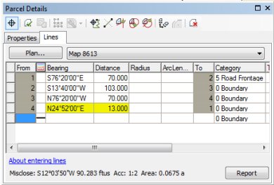
The dimension fields of a line in the traverse/construction grid are highlighted when the line shape differs from its bearing by more than 10 degrees and from its distance by more than 20 percent.

The inconsistent line can be caused by an erroneous dimension in the line itself or by an erroneous dimension of a different line in the traverse.
You can modify how and when erroneous lines are highlighted in the traverse grid by editing registry settings.
Turning off yellow highlighting in the traverse/construction grid
To turn off yellow highlighting in the traverse/construction grid, follow these steps:
- Click the windows Start menu and click Run
- Type regedit in the Run dialog box.
- In the Registry Editor window, navigate to HKEY_CURRENT_USER \\Software\\ESRI\\Desktop10.3\\ArcMap\\Cadastral.
- Right-click the Cadastral folder, point to New, then click DWORD value.
- Type ConsistencyReportOnNonCalcPoints as the DWORD name.
- Double-click the new DWORD value to edit it.
- In the Edit DWORD Value dialog box, choose the Decimal option.
- Type 0 (false) in the Value data text box to turn off yellow highlighting.
- Click OK to add the registry setting.
- Close the Registry Editor window.
Changing the angle limit that results in dimension highlighting
When lines are inconsistent with their shape geometry by more than 10 degrees, the line dimensions are highlighted.
To change the 10 degree default, follow these steps:
- In the Registry Editor window, navigate to HKEY_CURRENT_USER \\Software\\ESRI\\Desktop10.3\\ArcMap\\Cadastral.
- Right-click the Cadastral folder and click New > DWORD value.
- Type ConsistencyAngleDifference as the DWORD name.
- Double-click the new DWORD value to edit it.
- In the Edit DWORD Value dialog box, choose the Decimal option.
- Type the angle limit in decimal degrees in the Value data text box.
- Click OK to add the registry setting.
- Close the Registry Editor window.
Changing the distance percentage limit that results in dimension highlighting
When lines are inconsistent with their shape length by more that 20 percent, the line dimensions are highlighted.
To change the 20 percent default, follow these steps:
- In the Registry Editor window, navigate to HKEY_CURRENT_USER \\Software\\ESRI\\Desktop10.3\\ArcMap\\Cadastral.
- Right-click the Cadastral folder and click New > DWORD value.
- Type ConsistencyDistancePercentage as the DWORD name.
- Double-click the new DWORD value to edit it.
- In the Edit DWORD Value dialog box, choose the Decimal option.
- Type the percentage in the Value data text box.
- Click OK to add the registry setting.
- Close the Registry Editor window.