ArcGIS for Desktop

  • Documentation
  • Pricing
  • Support

  • My Profile
  • Help
  • Sign Out
ArcGIS for Desktop

ArcGIS Online

The mapping platform for your organization

ArcGIS for Desktop

A complete professional GIS

ArcGIS for Server

GIS in your enterprise

ArcGIS for Developers

Tools to build location-aware apps

ArcGIS Solutions

Free template maps and apps for your industry

ArcGIS Marketplace

Get apps and data for your organization

  • Documentation
  • Pricing
  • Support
Esri
  • Sign In
user
  • My Profile
  • Sign Out

Help

  • Home
  • Get Started
  • Map
  • Analyze
  • Manage Data
  • Tools
  • More...

Splitting lines using the Breakline tool

Available with Standard or Advanced license.

The Breakline tool is used to add construction points to lines to split them into smaller segments. The Breakline tool is often used when splitting a parcel using the Construct From Parent command.
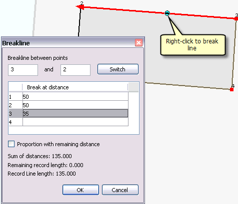
Breakline tool
Breakline tool

    To use the Breakline tool, follow these steps:
  1. Right-click the parcel line or parcel construction line to which you want to add construction points and click Breakline.
  2. A red line is displayed on the parcel line you right-clicked showing the direction in which the construction points will be added. To change the direction of the line, click Switch on the Breakline dialog box.
  3. Under Break at distance, enter the distances for each construction point.

    Tip:

    If you are creating multiple construction points at the same distance apart, you can add the distance and enter the number of times to create construction points at that distance; for example, to create three consecutive construction points at 50 feet apart, type 50 3 and press ENTER.

  4. Click the Proportion check box to change the length of the line on which you right-clicked. A new line is added that is proportioned to the sum of the construction point distances you entered.
  5. A change in line length might occur when new, more recent parcels are replacing a subdivision with older, less accurate dimensions. The sum of the new, more accurate parcel lengths might not be equal to the length of the older subdivision line.
  6. Click OK to add the construction points.

If you clicked Proportion, new lines are added to the construction grid for the new, proportioned segments. The original line on which you right-clicked is preserved and flagged as unbuildable. Unbuildable lines are not used to build new parcels.

Feedback on this topic?

ArcGIS for Desktop

  • Home
  • Documentation
  • Pricing
  • Support

ArcGIS Platform

  • ArcGIS Online
  • ArcGIS for Desktop
  • ArcGIS for Server
  • ArcGIS for Developers
  • ArcGIS Solutions
  • ArcGIS Marketplace

About Esri

  • About Us
  • Careers
  • Insiders Blog
  • User Conference
  • Developer Summit
Esri
© Copyright 2016 Environmental Systems Research Institute, Inc. | Privacy | Legal