Available with 3D Analyst license.
There are several surface display options available for LAS datasets in ArcScene. The LAS dataset surface is rendered as a triangulated surface model and behaves like a TIN layer. You are able to display the LAS dataset surface using elevation, slope, aspect, or contour lines based on certain lidar filters you apply to it. There are two methods available in ArcScene to display LAS datasets as a surface: use either the LAS Dataset toolbar or the Layer Properties symbology renderers.
How to display the LAS dataset as a surface using the LAS Dataset toolbar
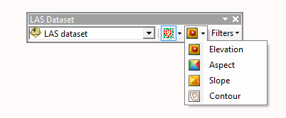
The LAS Dataset toolbar provides a quick way to display a LAS dataset as a surface. You can select from several symbology renderers to show the triangulated surface by elevation, slope, aspect, or contours.
To use the Display As TIN drop-down menu option to select a surface display renderer, follow the steps outlined below:
- Click the Add Data button
 from the Standard toolbar and browse to the LAS dataset. Click Add to add the LAS dataset layer to the table of contents in ArcScene.
- Add the LAS Dataset toolbar to the display in ArcScene by right-clicking the main menu and clicking LAS Dataset.
- Click the Display As TIN drop-down menu to select a specific surface renderer to display the LAS dataset surface. Choose either elevation, slope, aspect, or contour lines. Keep in mind that only one renderer can be applied to the surface at once.

How to display the LAS dataset as a surface using Layer Properties
Much like a TIN layer, the LAS dataset layer can have one or more surface renderers associated with it. To display your LAS dataset layer as a surface, simply select a face-based renderer from the list.
To select a renderer for a LAS dataset layer, follow these steps:
- Right-click the LAS dataset layer in the table of contents and click Properties.
- Click the Symbology tab.
- Remove (or uncheck) any existing renderers.
- Click Add to open the Add Renderer window.
- Choose the appropriate face-based renderer to see a surface, such as Faces with the same symbol.
- Click Addand click Dismiss to close the Add Renderer window.
- Optionally update the renderer properties.
- Click OK.
Related topics
- An overview of displaying LAS datasets
- Displaying LAS datasets as points in ArcMap
- Displaying LAS datasets as points in ArcScene
- Displaying LAS datasets as a surface in ArcMap
- Displaying LAS datasets in ArcScene at full resolution
- LAS dataset point display differences between ArcMap and ArcScene
- LAS dataset surface display differences between ArcMap and ArcScene