This topic describes how the current version of ArcGIS for Desktop can be used with a Metadata Service hosted by a previous version of ArcIMS.
ArcIMS Metadata Services don't require metadata to conform to any metadata standard. However, by default, Metadata Services require five pieces of information to be provided that support basic searches:
- Title—A name for the GIS resource that is appropriate for the entire community using the Metadata Service.
- Publisher—The name of the organization that is providing the resource.
- Spatial extent—The geographic location of the resource. If the resource is nonspatial and if an extent is not provided, searches won't find your resource; provide the extent of the globe instead.
- Theme—Choose at least one topic category for the resource. For example, for soil test data, theme codes for agriculture, geophysical, and environmental categories may all be relevant; if all are selected, searches in any of these categories will find this data's metadata.
- Content type—Select the type that best describes the resource. For example, for an internal Metadata Service, any resource provided in a shared folder on the network may be considered downloadable. For an Internet-based Metadata Service, a resource may only be considered downloadable if it can be saved from a Web page or transferred from an FTP location.
Although thumbnails aren't required, they are highly recommended because they are useful when evaluating search results.
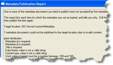
When metadata is published, it is checked to see if it contains this required information. If any is missing, the document won't be published. A report appears showing what information is missing.

The information required by ArcIMS Metadata Services and the validation performed to support it is unrelated to any metadata standard. Metadata that is valid for a metadata standard may not contain the information required by an ArcIMS Metadata Service. The type of validation supported when publishing metadata to an ArcIMS Metadata Service can't be enhanced, for example, to support XML schema validation.
Validation can be disabled for an ArcIMS Metadata Service. If the Metadata Service doesn't require validation, the metadata won't be validated, and any XML file can be published to the service. However, you might have difficulty finding the published document with a search.
Validating metadata
When metadata is published, ArcGIS looks for the required information in the appropriate ArcGIS and FGDC metadata elements. FGDC metadata elements are supported for publishing only to support metadata for legacy data where the metadata may not be upgraded to the current metadata standards or edited in the current version of ArcGIS.
Information in the ArcGIS metadata elements is preferred. That is, if a title is present in both the ArcGIS and FGDC metadata elements, the value in the ArcGIS metadata element will be used when naming the metadata document in the ArcIMS Metadata Service. Full-text searches using words in the FGDC metadata will still find the document, but searches that are specific to the title of the documents will only use words in the ArcGIS title.
When metadata containing only FGDC content is published, the theme keywords are examined for the appropriate theme codes such as utilitiesCommunication. Similarly, the resource description is examined for a content type code. See the ArcGIS Desktop 9.3.1 Help for information about the codes that ArcGIS will look for in metadata that hasn't been upgraded to the ArcGIS metadata format.