NetCDF (network Common Data Form) is a file format designed to support the creation, access, and sharing of scientific data. It is used extensively in the atmospheric and oceanographic communities to store variables, such as temperature, pressure, wind speed, and wave height.
NetCDF data are:
- Self-describing, meaning that a netCDF file includes information about the data it contains, such as when data elements were captured and what units of measurement were used.
- Portable, or cross-platform, in that a netCDF file created on one type of operating system can often be read by software on another type of operating system.
- Scalable, such that a small subset of a large netCDF file can be accessed efficiently without reading the entire file.

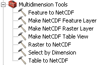
ArcGIS reads netCDF files natively, providing immediate access to the data without the need for data conversion or import. You cannot add a netCDF file using the Add Data button  in ArcGIS applications (ArcMap, ArcScene, or ArcGlobe). You can use theMake NetCDF Raster Layer, Make NetCDF Feature Layer, and Make NetCDF Table View tools from the Multidimension Tools toolbox to create a raster layer, a feature layer, and a table view, respectively, from a netCDF file.

You can also drag a netCDF file from Windows Explorer and drop it in the application.
