Multidimensional formats, including NetCDF, GRIB, and HDF, are often used in the scientific community to store meteorological and oceanographic data such as temperature, humidity, wind speed, and direction. Data is normally stored as variables, where each variable is a multidimensional array that represents data captured at multiple times, and multiple heights or pressures. The multidimensional mosaic dataset can be used to manage and process multidimensional data. See Creating a mosaic dataset using the Vector Field template topic to create a multidimensional mosaic dataset.
ArcGIS currently supports three multidimensional raster types: netCDF, GRIB, and HDF, which correspond to multidimensional raster data stored in those formats.
- GRIB—General Regularly-distributed Information in Binary
 is a concise data format commonly used in meteorology to store historical and forecast weather data. The GRIB raster type allows you to add GRIB 1 and GRIB 2 data into mosaic dataset. For a sample workflow, see Creating a mosaic dataset using the Vector Field template.
 - HDF—Hierarchical Data Format
 is a format designed by the National Center for Supercomputing Applications (NCSA) to store scientific data. The HDF raster type allows you to add raster data stored in HDF5 or HDF4 into a mosaic dataset. Nonraster data stored in a HDF file is ignored by the HDF raster type.
 - NetCDF—NetCDF (Network Common Data Form) is a file format for storing multidimensional data. Refer to Fundamentals of netCDF data storage for more information. Currently, netCDF raster types support Climate and Forecast(CF)
 and Cooperative Ocean/Atmosphere Research Data Service (COARDS) conventions. NetCDF files created using other conventions may work, but are not supported. For a sample workflow, see Creating and visualizing a netCDF mosaic dataset.
When you define a raster type, specify a processing template:
- Default—The raster data will be added to the mosaic dataset without any change in pixel value.
- Vector Field—Add raster data representing flow direction and magnitude, the mosaic dataset created with this template is easily visualized using Vector Field Renderer.
- Custom—Your custom template.
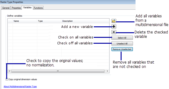
Specify variables to add to the mosaic dataset.

You can save a raster type with the varaible defined as a raster type template by clicking the Save As button on the General tab, so that you can reuse it within your organization.
Raster types supported by ArcGIS are listed in the Raster Type drop-down list on the Add Rasters To Mosaic Dataset tool. If your organization has created its own raster type, or if you have modified the properties for a raster type and saved it, you may have to browse to the *.art file to choose it.
Mosaic datasets can manage one or multiple variables. Whether you should put all variables in one mosaic dataset, or create one mosaic dataset per variable depends on the application. If your application only uses one variable, or a few independent variables, one mosaic per variable is easy to create, use, and manage.
Multiple variables in one mosaic dataset requires additional steps, such as quering and defining the statistics of the query or processing template, to make the display look good when accessing each variable. Due to all the additional steps, adding multiple variables to one mosaic dataset should only be used when it is necessary. If your application involves multiple variables, you want to access these variables in multiple ways, including access to each variable, and computing new variables from existing variables. For example, your variables might be temperature, relative humanity, and wind speed. From these variables, you can derive wind chill index and heat index. If you want to visualize all five of these variables, create one mosaic dataset to have all these variables added, then create five processing templates:
- A template that queries temperature
- A template that queries wind speed
- A template that queries humidity
- A template that computes a wind chill index
- A template that computes a heat index
For a sample workflow on how to create a mosaic dataset using the Vector Field template, see Creating a mosaic dataset using the Vector Field template.
To see how to add custom templates to a mosaic dataset, see Adding a processing template to a mosaic dataset.