ArcGIS for Desktop

  • Documentation
  • Pricing
  • Support

  • My Profile
  • Help
  • Sign Out
ArcGIS for Desktop

ArcGIS Online

The mapping platform for your organization

ArcGIS for Desktop

A complete professional GIS

ArcGIS for Server

GIS in your enterprise

ArcGIS for Developers

Tools to build location-aware apps

ArcGIS Solutions

Free template maps and apps for your industry

ArcGIS Marketplace

Get apps and data for your organization

  • Documentation
  • Pricing
  • Support
Esri
  • Sign In
user
  • My Profile
  • Sign Out

Help

  • Home
  • Get Started
  • Map
  • Analyze
  • Manage Data
  • Tools
  • More...

How to use the LAS To Multipoint tool

Available with 3D Analyst license.

Follow these steps to use the LAS To Multipoint geoprocessing tool to import one or more LAS files into a multipoint feature class. ArcGIS supports LAS versions 1.0, 1.1, 1.2, and 1.3. The waveform information that is available when using LAS version 1.3 is not supported. Additionally, LAS version 1.4 files that are 1.3 compliant.

Each LAS file contains metadata of the lidar survey in a header block followed by individual records for each laser pulse recorded.

  1. In ArcToolbox, expand 3D Analyst Tools, expand the Conversion tools, then expand the From File tools.
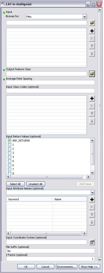
  2. Double-click the LAS To Multipoint tool to open it. The LAS to Multipoint dialog box appears (see below).
  3. From the Input Browse for drop-down menu, choose either Folders or Files.
  4. Click the Input Browse button Browse to navigate to the LAS files you want to import.
  5. Highlight the LAS files you want to import and click Open. You can use the SHIFT or CTRL key to select more than one LAS file.
  6. Click the Output Feature Class browse button Browse to set the location of the output feature class. All feature classes contributing to a terrain dataset must reside in the same feature dataset. It is recommended that you set the output feature class to be the feature dataset where the terrain dataset will be created.
  7. Set the Average Point Spacing for the input LAS data.
  8. Optionally, specify an Input Class Code.
  9. Optionally, type an Input Return Value.
  10. Optionally, specify Input Attribute Names.
  11. Optionally, specify an Input Coordinate System.
  12. Optionally, set the File suffix.
  13. Click OK.
  14. LAS to MULTIPOINT Geoprocessing Tool
    LAS To Multipoint Geoprocessing Tool
    Note:
    • ArcGIS supports LAS versions 1.0, 1.1, 1.2, and 1.3. The waveform information that is available when using LAS version 1.3 is not supported. Additionally, LAS version 1.4 files that are 1.3 compliant.
    • Choose Files if the input source measurements are contained within one or two files. Choose Folders if the desired input source measurements are contained within several input files located within the same directory.
    • If you aren't interested in importing points based on their return number, or if all returns specified in the files are set to 0 because the points have been filtered or classified, check ANY_RETURNS.
    • When loading multiple LAS attributes into an Oracle database, you'll need to make sure all dbtune keywords for the parameter attribute_binary are set to use BLOBs, not LONGRAW. This is because LAS attributes are loaded as BLOBs, and Oracle does not support multiple BLOBS in LONGRAW tables. See your Oracle database administrator for assistance.

Related Topics

  • Importing terrain dataset source measurements
  • LAS To Multipoint
  • Types of source data supported in terrain datasets
  • Representing terrain source data in feature classes
Feedback on this topic?

ArcGIS for Desktop

  • Home
  • Documentation
  • Pricing
  • Support

ArcGIS Platform

  • ArcGIS Online
  • ArcGIS for Desktop
  • ArcGIS for Server
  • ArcGIS for Developers
  • ArcGIS Solutions
  • ArcGIS Marketplace

About Esri

  • About Us
  • Careers
  • Insiders Blog
  • User Conference
  • Developer Summit
Esri
© Copyright 2016 Environmental Systems Research Institute, Inc. | Privacy | Legal