ArcGIS for Desktop

  • Documentation
  • Pricing
  • Support

  • My Profile
  • Help
  • Sign Out
ArcGIS for Desktop

ArcGIS Online

The mapping platform for your organization

ArcGIS for Desktop

A complete professional GIS

ArcGIS for Server

GIS in your enterprise

ArcGIS for Developers

Tools to build location-aware apps

ArcGIS Solutions

Free template maps and apps for your industry

ArcGIS Marketplace

Get apps and data for your organization

  • Documentation
  • Pricing
  • Support
Esri
  • Sign In
user
  • My Profile
  • Sign Out

Help

  • Home
  • Get Started
  • Map
  • Analyze
  • Manage Data
  • Tools
  • More...

Pyramid resolution bounds

Available with 3D Analyst license.

  • Setting pyramid resolution bounds

Minimum and maximum resolution bounds are used for feature classes added as polyline or polygon surface feature types. They define the range of pyramid levels at which the features will be enforced in the surface. You provide the resolution thresholds, given in the resolution of the terrain's pyramid levels.

Setting pyramid resolution bounds

Once the pyramid level definition has been completed, the pyramid resolution bounds can be set if necessary.

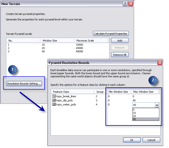
  1. Click the Resolution Bounds Setting button on the New Terrain dialog box to access the Pyramid Resolution Bounds dialog box.
  2. Click in the specific column where you want to change the default minimum and/or maximum pyramid bound.
  3. Choose the desired pyramid level from the drop-down list for each feature class participating in the terrain dataset.
  4. Click OK.
minimum and maximum pyramid resolution bounds
Setting the minimum and maximum pyramid resolution bounds

Related Topics

  • Terrain pyramids
  • Terrain dataset concepts
  • Terrain scalability
  • Building a terrain dataset using the New Terrain wizard
Feedback on this topic?

ArcGIS for Desktop

  • Home
  • Documentation
  • Pricing
  • Support

ArcGIS Platform

  • ArcGIS Online
  • ArcGIS for Desktop
  • ArcGIS for Server
  • ArcGIS for Developers
  • ArcGIS Solutions
  • ArcGIS Marketplace

About Esri

  • About Us
  • Careers
  • Insiders Blog
  • User Conference
  • Developer Summit
Esri
© Copyright 2016 Environmental Systems Research Institute, Inc. | Privacy | Legal