ArcGIS for Desktop

  • Documentation
  • Pricing
  • Support

  • My Profile
  • Help
  • Sign Out
ArcGIS for Desktop

ArcGIS Online

The mapping platform for your organization

ArcGIS for Desktop

A complete professional GIS

ArcGIS for Server

GIS in your enterprise

ArcGIS for Developers

Tools to build location-aware apps

ArcGIS Solutions

Free template maps and apps for your industry

ArcGIS Marketplace

Get apps and data for your organization

  • Documentation
  • Pricing
  • Support
Esri
  • Sign In
user
  • My Profile
  • Sign Out

Help

  • Home
  • Get Started
  • Map
  • Analyze
  • Manage Data
  • Tools
  • More...

Add TIN Point interactive tool

Available with 3D Analyst license.

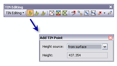
To add individual nodes to an editable TIN, use the Add TIN Point interactive tool Add TIN Point from the TIN Editing toolbar.

Add TIN Point interactive tool

When the tool is clicked, a dialog box appears that enables you to specify the height properties for the digitized points. The following steps describe how to interactively add points to a TIN surface.

  1. Click the TIN Editing drop-down arrow and click Start Editing TIN.
  2. Click the Add TIN Point tool from the TIN Editing toolbar. The Add TIN Point dialog window appears.
  3. From the Add TIN Point dialog window, set Height source to either From Surface or As Specified. When the From Surface option is selected, the elevation of the digitized TIN node is interpolated from the selected location on the surface. When the As Specified option is selected, the digitized TIN node is specified in the height field.
  4. Enter the new elevation points onto the TIN surface by clicking the desired locations.

Related Topics

  • The interactive TIN Editing toolbar
  • What is a TIN surface?
Feedback on this topic?

ArcGIS for Desktop

  • Home
  • Documentation
  • Pricing
  • Support

ArcGIS Platform

  • ArcGIS Online
  • ArcGIS for Desktop
  • ArcGIS for Server
  • ArcGIS for Developers
  • ArcGIS Solutions
  • ArcGIS Marketplace

About Esri

  • About Us
  • Careers
  • Insiders Blog
  • User Conference
  • Developer Summit
Esri
© Copyright 2016 Environmental Systems Research Institute, Inc. | Privacy | Legal