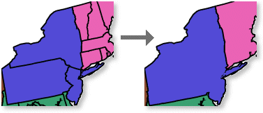
Cartographers often need to control the order in which symbols are drawn on maps. This is accomplished using symbol level drawing in ArcMap.
Symbol level drawing allows you to control the drawing order of feature symbology and controls how line symbols connect to each other. Using symbol level drawing, you can specify the order that symbols and symbol layers for multilayer symbols are drawn on your map, overriding the default ArcMap drawing sequence. With symbol level drawing, you specify the drawing order for each symbol and its position within the context of other symbols. Symbol level drawing parameters may be set individually for each feature layer as well as for group layers.
Symbol level drawing is accessed from the Advanced button on the Symbology tab of the Layer Properties dialog box. 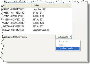
Learn more about working with symbol level drawing
How does symbol level drawing work?
When you use symbol level drawing, you override the ArcMap default drawing sequence. In the default sequence, features are first drawn according to the order of layers in the table of contents (from bottom to top). Then, within each layer, features are drawn based on the table order—that is, the order that features are stored in the feature class table (or in the order that they are returned from the geodatabase). When you enable symbol level drawing, you override this mechanism.
You can work with symbol levels in two different views: default view and advanced view. Default view lets you quickly create maps with common cartographic effects by setting Join and Merge settings for your symbols. Advanced view allows you to create more complex effects.
Conceptually, you can take this one step further by specifying that a given symbol will show a connectivity effect when it intersects one other type of symbol but not with any other symbol.
You can work with symbol level drawing in ArcMap at two levels: feature layer and group layer. By default, symbol level drawing is off for all layers. You can turn on symbol level drawing only for layers where you want the effect.
What can you do with symbol level drawing?
Symbol level drawing is useful for achieving some graphic effects that can give your maps a polished cartographic look, for example, to symbolize overlapping and intersecting line features with cased-line symbols. On a large-scale reference map with intersecting streets, you can create high-quality representations of streets. Where streets intersect, you can blend the symbology for connectivity or not so that you can represent overpasses or underpasses. 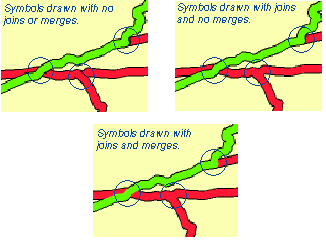
Symbolize overlapping and intersecting roads using high-quality, cased-line symbology
To display connected streets (for example, residential streets) in ArcMap, you can use symbol level drawing. Specify that the given multilayer symbol is joined. When a symbol is joined, all features assigned to the symbol are displayed as joined when they intersect each other on the map. 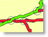
You can specify that your highway features only show the connectivity effect when they intersect other highway or highway ramp features (symbolized with a highway ramp symbol). However, when highway features intersect other street types, such as surface streets, they will not be connected. 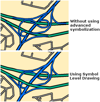
In symbol level terminology, the highway symbol is merged with the highway ramp symbol, but it is not merged with the surface street symbol.
Draw features in a specific order
Using unique values symbology with symbol level drawing, you can specify the exact drawing order of overlapping features. You might do this is if you have a layer of overlapping polygons. By drawing these features in order from largest to smallest, you increase the number of visible features on your map. In ArcMap, you can do this using symbol level drawing.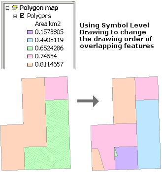
Dissolve boundary lines between polygon features with the same attribute values
Using symbol level drawing in ArcMap, you can eliminate boundaries between polygon areas with the same attribute value. This achieves the same visual effect as dissolving features based on an attribute without having to process the feature geometry.