The label offset controls the distance a label is placed from its feature. The offset is measured from the boundary of the feature symbol to the outer edge of the label. The boundary for simple geometric symbols is the edge of the symbol; for graphic and font symbols, the bounding rectangle around the symbol is the symbol boundary unless you check the Maplex Label Engine's Measure offset from the exact symbol outline check box. A value of 0 will cause the label to touch the symbol boundary. To measure the offset from the feature geometry instead of the edge of the symbol, check the Measure offset from the feature geometry check box.
You can specify a distance measured in map units, inches, millimeters, or points for the offset. The label is placed at that offset distance according to the placement position.
If the offset distance cannot be honored (for example, because of label or feature conflicts), the label will be placed within the maximum distance, which is a percentage of the offset distance. The default value for the maximum distance is 100 percent of, or equal to, the offset distance. A maximum distance value of 200 percent would allow the label to be placed up to twice the offset distance from the feature. If the Maplex Label Engine cannot place the label at the offset distance, it will try to place the label farther from the feature, up to the maximum distance.
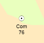
The image below shows the point feature labeled with a label offset of 5 points.

- Enable the Maplex Label Engine.
- Click the Label Manager button
 on the Labeling toolbar.
- Check the check box next to the layer you want to label.
- Choose a label class under the layer.
- Click the Properties button.
- Click the Label Position tab.
- Click Label Offset.
- Enter the distance for the preferred offset value.
- Choose a measurement unit from the drop-down list.
- Enter the maximum offset value as a percentage.
- Optionally, click the Measure offset from the feature geometry check box.
- Optionally, click the Measure offset from the exact symbol outline check box.
- Click OK to close all dialog boxes.
These units are measured in map units or in page units (millimeters, inches, or points).