ArcGIS for Desktop

  • Documentation
  • Pricing
  • Support

  • My Profile
  • Help
  • Sign Out
ArcGIS for Desktop

ArcGIS Online

The mapping platform for your organization

ArcGIS for Desktop

A complete professional GIS

ArcGIS for Server

GIS in your enterprise

ArcGIS for Developers

Tools to build location-aware apps

ArcGIS Solutions

Free template maps and apps for your industry

ArcGIS Marketplace

Get apps and data for your organization

  • Documentation
  • Pricing
  • Support
Esri
  • Sign In
user
  • My Profile
  • Sign Out

Help

  • Home
  • Get Started
  • Map
  • Analyze
  • Manage Data
  • Tools
  • More...

Working with contours

Available with 3D Analyst license.

Contours are lines that connect points of equal value (such as elevation, temperature, precipitation, pollution, or atmospheric pressure). The distribution of the lines shows how values change across a surface. Where there is little change in values, the lines are spaced farther apart. Where the values rise or fall rapidly, the lines are closer together.

By following the line of a particular contour, you can identify which locations have the same value. By looking at the spacing of adjacent contours, you can gain a general impression of the gradation of values.

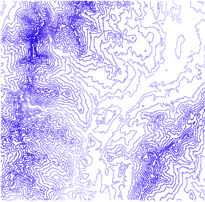
The example below shows an input elevation grid and the output contour map. The areas where the contours are closer together indicate the steeper locations. They correspond with the areas of higher elevation (in white on the input elevation grid).
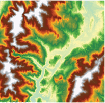
An input elevation grid
The output contour map

The attribute table of the contour features contains an elevation attribute for each contour line.

Related Topics

  • An overview of the Triangulated Surface toolset
  • Fundamentals of geoprocessing with the ArcGIS 3D Analyst extension
  • Fundamentals of Surfaces
  • Understanding the shape of a surface
  • Contours and isolines
Feedback on this topic?

ArcGIS for Desktop

  • Home
  • Documentation
  • Pricing
  • Support

ArcGIS Platform

  • ArcGIS Online
  • ArcGIS for Desktop
  • ArcGIS for Server
  • ArcGIS for Developers
  • ArcGIS Solutions
  • ArcGIS Marketplace

About Esri

  • About Us
  • Careers
  • Insiders Blog
  • User Conference
  • Developer Summit
Esri
© Copyright 2016 Environmental Systems Research Institute, Inc. | Privacy | Legal