ArcGIS for Desktop

  • Documentation
  • Pricing
  • Support

  • My Profile
  • Help
  • Sign Out
ArcGIS for Desktop

ArcGIS Online

The mapping platform for your organization

ArcGIS for Desktop

A complete professional GIS

ArcGIS for Server

GIS in your enterprise

ArcGIS for Developers

Tools to build location-aware apps

ArcGIS Solutions

Free template maps and apps for your industry

ArcGIS Marketplace

Get apps and data for your organization

  • Documentation
  • Pricing
  • Support
Esri
  • Sign In
user
  • My Profile
  • Sign Out

Help

  • Home
  • Get Started
  • Map
  • Analyze
  • Manage Data
  • Tools
  • More...

Spatial relationships by feature type

A spatial join involves matching rows from the join layer to the target layer based on a spatial relationship and writing to an output feature class. The spatial relationship is determined by the geometry types of the input layers as well as the chosen match option.

The table below shows which spatial relationship is valid (tick mark) for which combination of geometry types.

The relationships of INTERSECT, INTERSECT_3D, WITHIN_A_DISTANCE, WITHIN_A_DISTANCE_3D, and CLOSEST are not shown in the table, as these are valid for any combination of geometry type.
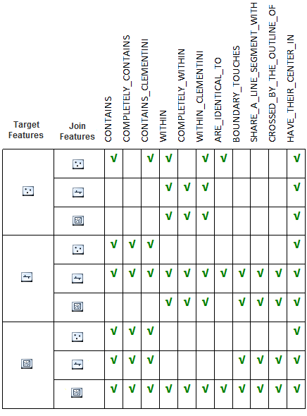
Valid spatial relationships by combinations of feature types
Spatial relationships by feature geometry types
Feedback on this topic?

ArcGIS for Desktop

  • Home
  • Documentation
  • Pricing
  • Support

ArcGIS Platform

  • ArcGIS Online
  • ArcGIS for Desktop
  • ArcGIS for Server
  • ArcGIS for Developers
  • ArcGIS Solutions
  • ArcGIS Marketplace

About Esri

  • About Us
  • Careers
  • Insiders Blog
  • User Conference
  • Developer Summit
Esri
© Copyright 2016 Environmental Systems Research Institute, Inc. | Privacy | Legal