ArcGIS for Desktop

  • Documentation
  • Pricing
  • Support

  • My Profile
  • Help
  • Sign Out
ArcGIS for Desktop

ArcGIS Online

The mapping platform for your organization

ArcGIS for Desktop

A complete professional GIS

ArcGIS for Server

GIS in your enterprise

ArcGIS for Developers

Tools to build location-aware apps

ArcGIS Solutions

Free template maps and apps for your industry

ArcGIS Marketplace

Get apps and data for your organization

  • Documentation
  • Pricing
  • Support
Esri
  • Sign In
user
  • My Profile
  • Sign Out

Help

  • Home
  • Get Started
  • Map
  • Analyze
  • Manage Data
  • Tools
  • More...

How Assign by Closest Stores Location works

To create customer derived trade areas around your customers or to create desire lines, your customer data must contain a field that associates each customer with a particular store. A number of analyses in Esri Business Analyst require that your customer data has a store assignment field. If you do not have such a field, you can create one using the Assign by Closest Stores Location tool. This method assigns each customer the ID of the store that is closest by straight-line distance.

The image below illustrates how these assignments are made. The image has two store locations (yellow and blue squares) and a set of customers (red triangles). In this simplified example, each of the customer points will inherit the store ID of the closest store location.
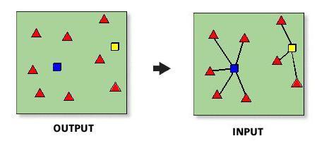
Assign Stores

You cannot undo the assignment of customers to stores in an existing field. Be careful not to overwrite an existing field.

Feedback on this topic?

ArcGIS for Desktop

  • Home
  • Documentation
  • Pricing
  • Support

ArcGIS Platform

  • ArcGIS Online
  • ArcGIS for Desktop
  • ArcGIS for Server
  • ArcGIS for Developers
  • ArcGIS Solutions
  • ArcGIS Marketplace

About Esri

  • About Us
  • Careers
  • Insiders Blog
  • User Conference
  • Developer Summit
Esri
© Copyright 2016 Environmental Systems Research Institute, Inc. | Privacy | Legal