Available with Advanced license.
Summary
Derives centerlines (single lines) from dual-line features, such as road casings, based on specified width tolerances.
Learn more about how Collapse Dual Lines To Centerline works
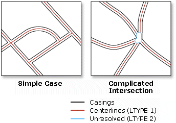
Illustration

Usage
In addition to the standard items, the Output Coverage.AAT will contain the following five new items:
- LTYPE—Contains a line type value of:
1 centerlines 2 unused lines and outlines of complicated intersections 3 partition lines - LL#—Carries the left source arc record number.
- RL#—Carries the right source arc record number.
- L-ID—Carries the left source arc user ID.
- R-ID—Carries the right source arc user ID.
- LTYPE—Contains a line type value of:
The values for item_width, output_width, and item_type in the item definition for all these items are 4, 5, and B.
Syntax
CollapseDualLinestoCenterline_arc (in_cover, out_cover, maximum_width, {minimum_width})| Parameter | Explanation | Data Type |
in_cover | The coverage containing near parallel dual lines, such as road casings, from which centerlines are derived. | Coverage |
out_cover | The output coverage containing the derived centerlines. The output coverage name must be different from the input coverage name. | Coverage |
maximum_width | Sets the maximum width in coverage units. | Double |
minimum_width (Optional) | Sets the minimum width in coverage units. The default is zero. | Double |
Code Sample
CollapseDualLinesToCenterline example (stand-alone script)
The following stand-alone script demonstrates how to create a line coverage of street centerlines from a line coverage of street casings.
# Name: CollapseDualLinesToCenterline_Example.py
# Description: Creates street centerlines from a street casing coverage.
# Requirements: ArcInfo Workstation

# Import system modules
import arcpy
from arcpy import env

# Set environment settings
env.workspace = "C:/data"

# Set local variables
inCover = "streets"
outCover = "C:/output/centerlines"
maximumWidth = 50

# Execute CollapseDualLinesToCenterline
arcpy.CollapseDualLinesToCenterline_arc(inCover, outCover, maximumWidth, "")
Environments
Licensing Information
- ArcGIS for Desktop Basic: No
- ArcGIS for Desktop Standard: No
- ArcGIS for Desktop Advanced: Requires ArcInfo Workstation installed